Data Sets » Theme: UrbanRemove Facet
1 of 3
Prev | Next

Annual Global High-Resolution Extreme Heat Estimates (GEHE), v1 (1983 – 2016)

Satellite-Derived Environmental Indicators

To provide a high-resolution, longitudinal global data set of annual extreme humid-heat.

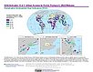
SDG Indicator 11.2.1: Urban Access to Public Transport, 2023 Release (2015 – 2022)

Sustainable Development Goal Indicators (SDGI)

To provide urban center level estimates of the proportion of population that has convenient access to public transportation.

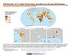
SDG Indicator 11.7.1: Urban Public Space, Availability and Access, 2023 Release (2015 – 2022)

Sustainable Development Goal Indicators (SDGI)

To provide urban center level estimates of the average share of the built-up area of cities that is open space for public use for all.

Yale Center for Earth Observation (YCEO) Surface Urban Heat Islands, v4 (2003 – 2018)

Satellite-Derived Environmental Indicators

To provide global estimates of the surface urban heat island intensity from monthly, seasonal, to annual scales for over 10,000 urban clusters developed using a simplified urban-extent algorithm.

Sub-global Scenarios that Extend the Global SSP Narratives: Literature Database, v1 (2014 – 2021)

Shared Socioeconomic Pathways (SSPs)

To provide a literature database tracking the use of the sub-global scenarios consisting of Shared Socioeconomic Pathways (SSPs) and Representative Concentration Pathways (RCPs) that extend the global SSP narratives and framework for climate, socioeconomic, environmental, and other related research.

Global (GL) Annual PM2.5 Grids from MODIS, MISR and SeaWiFS Aerosol Optical Depth (AOD), v4.03 (1998 – 2019)

Satellite-Derived Environmental Indicators

To provide an annual global surface of concentrations (micrograms per cubic meter) of all composition ground-level fine particulate matter of 2.5 micrometers or smaller (PM2.5) for large-scale health and environmental research.

Global Monthly and Seasonal Urban and Land Backscatter Time Series, v1 (1993 – 2020)

Urban Spatial Data

To provide a 28-year time series of microwave backscatter to support analysis of patterns and trends in growth of global urban building infrastructure.

Country Trends in Major Air Pollutants, v1 (2003 – 2018)

Air Quality Data for Health-Related Applications

To provide a framework of public-health-focused air quality indicators that quantifies country trends in exposure to major air pollutants.

Daily and Annual PM2.5, O3, and NO2 Concentrations at ZIP Codes for the Contiguous U.S., v1 (2000 – 2016)

Air Quality Data for Health-Related Applications

To provide daily and annual Fine Particulate Matter (PM2.5), Ozone (O3), and Nitrogen Dioxide (NO2) concentrations data at ZIP Codes for the contiguous U.S. for research in environmental epidemiology, environmental justice, and health equity by linking with ZIP Code-level demographic and medical data sets, and for other related research.

Annual PM2.5 Concentrations for Countries and Urban Areas, v1 (1998 – 2016)

Satellite-Derived Environmental Indicators

To provide an annual global surface of concentrations (micrograms per cubic meter) of mineral dust and sea-salt filtered fine particulate matter of 2.5 micrometers or smaller (PM2.5) in countries and urban areas for large-scale health and environmental research

Population (POP), Built-Up Estimates (BUILT), and Degree of Urbanization Settlement Model Grid (SMOD), v1 (1975, 1990, 2000, 2014, 2015)

Global Human Settlement Layer (GHSL)

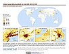
To provide global data on human population, built up area, and degree of urbanization for the years 1975, 1990, 2000, and 2014/2015 in the World Geodetic System 1984 (WGS84) geographic coordinate system.

Global 1-km Downscaled Urban Land Extent Projection and Base Year Grids by SSP Scenarios, v1 (2000 – 2100)

Shared Socioeconomic Pathways (SSPs)

To provide global SSP-consistent spatial urban land projections and base year grids based on the Shared Socioeconomic Pathways (SSPs) data at a resolution of 1-km (about 30 arc-seconds) for climate, socioeconomic, environmental, and other related research.

Global High Resolution Daily Extreme Urban Heat Exposure (UHE-Daily), v1 (1983 – 2016)

Satellite-Derived Environmental Indicators

To provide a high-resolution, longitudinal global data set of extreme urban heat events and urban heat exposure.

SSPs Literature Database, v1 (2014 – 2019)

Shared Socioeconomic Pathways (SSPs)

To provide a literature database tracking the use of a global scenarios framework consisting of Shared Socioeconomic Pathways (SSPs), Representative Concentration Pathways (RCPs), and Shared Policy Assumptions (SPAs), for climate, socioeconomic, environmental, and other related research.

Urban Extent Polygons, v1.02 (1995)

Global Rural-Urban Mapping Project (GRUMP), v1

To provide a polygon representation of urban areas with city or agglomeration name and time series population estimates.

VIIRS Plus DMSP Change in Lights (VIIRS+DMSP dLIGHT), v1 (1992, 2002, 2013)

Satellite-Derived Environmental Indicators

To visualize changes in brightness and extent of global nighttime lights networks over two decades with improved radiometric accuracy and finer spatial resolution.

Global Human Modification of Terrestrial Systems, v1 (2016)

Land Use and Land Cover

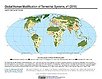
To provide a cumulative measure of human modification of terrestrial lands based on modeling the physical extents of 13 anthropogenic stressors and their estimated impacts using spatially-explicit global data sets.

Global Development Potential Indices, v1 (2016)

Land Use and Land Cover

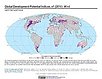
To provide spatially-explicit data that relatively rank global land suitability referred to as Development Potential Indices (DPIs) for 13 sectors related to renewable energy, fossil fuels, mining and agriculture as an aid to conservation priority setting.

Development Threat Index, v1 (2015)

Land Use and Land Cover (LULC)

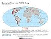
To provide a future development threat map based on combining these resources: agricultural expansion, urban expansion, conventional oil and gas, unconventional oil and gas, coal, mining, biofuels, solar, and wind.

Urban Extents from VIIRS and MODIS for the Continental U.S. Using Machine Learning Methods, v1 (2015)

Urban Spatial Data

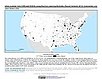
To provide representations of urban areas in the Continental U.S. in the year 2015 to support sustainable urban development planning in accordance with the growth of urban areas.

Data Sets » Theme: UrbanRemove Facet
1 of 3
Prev | Next