Data Sets (64)
| 2 of 4 |
Population, Landscape, And Climate Estimates (PLACE), v3 (1990, 2000, 2010)National Aggregates of Geospatial Data Collection (NAGDC)
To provide tabular data to researchers without GIS capabilities who need data on population and land area by country across a range of physical characteristics. These include measures such as the number of persons living within coastal zones, the percent of a region within specific elevation strata, or the number of persons living within different climate zones. |
||
Population Count Grid, v1 (1990, 1995, 2000)Global Rural-Urban Mapping Project (GRUMP), v1To provide a time series of raster population data for ntegration with other data sets. |
Urban Extents Grid, v1 (1995)Global Rural-Urban Mapping Project (GRUMP), v1
To provide a raster representation of urban areas (or urban mask) for use with GRUMP population grids or other data sets. |
|
Land and Geographic Unit Area Grids, v1 (2000)Global Rural-Urban Mapping Project (GRUMP), v1To provide land area data for use with GRUMPv1 population and urban data as well as a quantitative measure of resolution of the input spatial units for GRUMPv1. |
Population Density Grid, v1 (1990, 1995, 2000)Global Rural-Urban Mapping Project (GRUMP), v1
To provide a time series of raster population density data for data integration. |
|
Settlement Points, v1 (1990, 1995, 2000)Global Rural-Urban Mapping Project (GRUMP), v1
To provide populated place (point) data with consistent population estimates. |
Environmental Performance Index, 2010 Release (
|
|
Change in Chlorophyll-a Concentration, v1 (
|
||
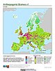
Synthetic Assessment of Global Distribution of Vulnerability to Climate Change, v1 (2005, 2050, 2100)Intergovernmental Panel on Climate Change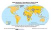
To provide geographical portraits of vulnerability designed to incorporate both exposure to climate change and national capacities to adapt. |
||
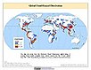
Global Flood Hazard Frequency and Distribution, v1 (
|
Global Landslide Mortality Risks and Distribution, v1 (2000)Natural Disaster Hotspots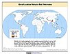
To provide a means of assessing global landslide mortality risks and distribution. |
|
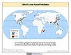
Global Cyclone Hazard Frequency and Distribution, v1 (
|
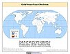
Global Volcano Hazard Frequency and Distribution, v1 (
|
|
Global Drought Total Economic Loss Risk Deciles, v1 (2000)Natural Disaster Hotspots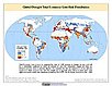
To provide a spatial surface of the total economic impacts of global drought hazard. |
Global Volcano Proportional Economic Loss Risk Deciles, v1 (2000)Natural Disaster Hotspots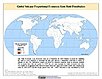
To provide a spatial surface of the proportional economic impacts of global volcano hazard. |

| 2 of 4 |