Data Sets (28)
|
2 of 2
Prev
|
Next
|
Global Drought Proportional Economic Loss Risk Deciles, v1 (2000)Natural Disaster Hotspots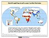
To provide a spatial surface of the proportional economic impacts of global drought hazard. |
Global Drought Mortality Risks and Distribution, v1 (2000)Natural Disaster Hotspots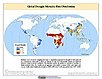
To provide a means of assessing global drought mortality risks and distribution. |
|
Global Flood Total Economic Loss Risk Deciles, v1 (2000)Natural Disaster Hotspots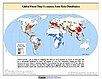
To provide a spatial surface of the total economic impacts of global flood hazard. |
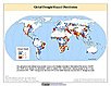
Global Flood Proportional Economic Loss Risk Deciles, v1 (2000)Natural Disaster Hotspots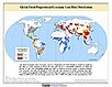
To provide a spatial surface of the proportional economic impacts of global flood hazard. |
|
Global Flood Mortality Risks and Distribution, v1 (2000)Natural Disaster Hotspots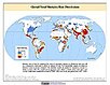
To provide a means of assessing global flood mortality risks and distribution. |
Global Drought Hazard Frequency and Distribution, v1 (
|
|
Global Mangrove Forests Distribution, v1 (2000)Land Use and Land Cover
To provide data that can be used in global mangrove forest distribution modeling, land cover change analysis, global carbon accounting studies and to assist with policy-making in regards to human-environment interactions and future adaptive strategies. |
Environmental Sustainability Index, 2005 Release (
|
|
2 of 2
Prev
|
Next
|