Superfund Site Footprints
To provide the ATSDR polygon data set of hazardous waste sites in the United States, Puerto Rico, and other territories which can be used to identify nearby populations and assess their potential risk.
|
|
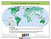
Environmental Performance Index (EPI)
To provide quantitative metrics for evaluating a country's environmental performance in different policy categories relative to clearly defined targets.
|
Indicators of Coastal Water Quality
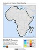
To provide tabular data on the trends of chlorophyll-a concentration on a pixel by pixel basis for identifying areas with improving, declining, and stable coastal water quality that can provide guidance for decision making in the context of coastal management.
|
|
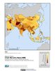
Climate Effects on Food Supply
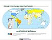
To provide an assessment of potential climate change impacts on world crop production.
|
Environmental Performance Index (EPI)
To provide quantitative metrics for evaluating a country's environmental performance in different policy categories relative to clearly defined targets.
|
|
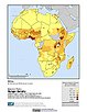
Poverty Mapping
To provide high spatial resolution subnational estimates of poverty and inequality for use by a wide user community for interdisciplinary studies of poverty, inequality and the environment.
|
Poverty Mapping
To provide a global subnational map of the prevalence of underweight children that can be used by a wide user community in interdisciplinary studies of health, poverty and the environment.
|
|
Poverty Mapping
To provide a global subnational map of infant mortality rate estimates that can be used by a wide user community in interdisciplinary studies of health, poverty and the environment.
|
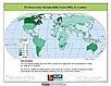
Environmental Sustainability Index (ESI)
To create a comparative index of national-level environmental sustainability and to provide a mechanism for making environmental management more quantitative, empirically grounded and systematic.
|
|
Environmental Sustainability Index (ESI)
To provide a comparative index of national-level environmental sustainability covering a number of sustainability dimensions.
|