Data Sets » Theme: Remote SensingRemove Facet » Format: mapRemove Facet
2 of 2
Prev | Next

Croplands, v1 (2000)

Global Agricultural Lands

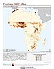
To provide data on the extent of croplands for research on human-environment interactions.

Pastures, v1 (2000)

Global Agricultural Lands

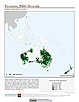
To provide data on the extent of pasturelands for research on human-environment interactions.

Change in Chlorophyll-a Concentration, v1 (1998 – 2007)

Indicators of Coastal Water Quality

To provide tabular data on the trends of chlorophyll-a concentration on a pixel by pixel basis for identifying areas with improving, declining, and stable coastal water quality that can provide guidance for decision making in the context of coastal management.

Anthropogenic Biomes of the World, v1 (2001 – 2006)

Anthropogenic Biomes

To provide information on global land use for research on human-environment interactions.

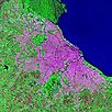
Urban Landsat: Cities from Space, v1 (1999 – 2003)

Global High Resolution Urban Data from Landsat

To serve a wide user community by providing composite Landsat images and raw data for urban areas that can be used in interdisciplinary studies of remote sensing and the environment.

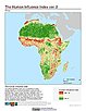
Global Human Influence Index (Geographic), v2 (1995 – 2004)

Last of the Wild, v2

To provide an updated map of anthropogenic impacts on the environment in geographic projection which can be used in wildlife conservation planning, natural resource management, and research on human-environment interactions.

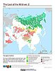
Last of the Wild (Geographic), v2 (1995 – 2004)

Last of the Wild, v2

To provide an updated map of wild areas in geographic projection which can be used in wildlife conservation planning, natural resource management, and research on human-environment interactions.

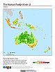
Global Human Footprint (Geographic), v2 (1995 – 2004)

Last of the Wild, v2

To provide an updated map of anthropogenic impacts on the environment in geographic projection which can be used in wildlife conservation planning, natural resource management, and research on human-environment interactions.

Global Mangrove Forests Distribution, v1 (2000)

Land Use and Land Cover

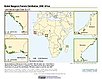
To provide data that can be used in global mangrove forest distribution modeling, land cover change analysis, global carbon accounting studies and to assist with policy-making in regards to human-environment interactions and future adaptive strategies.

Global Patterns in Net Primary Productivity, v1 (1995)

Human Appropriation of Net Primary Productivity (HANPP)

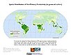
To be utilized in conjunction with a data set of human appropriation of net primary productivity (HANPP) in order to understand global energy flows and localized impacts on the environment.

HANPP as a Percentage of Net Primary Productivity, v1 (1995)

Human Appropriation of Net Primary Productivity (HANPP)

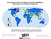
To identify spatial variations in the amount of NPP consumption relative to local production in a way that highlight humanity's growing impact on the biosphere.

Data Sets » Theme: Remote SensingRemove Facet » Format: mapRemove Facet
2 of 2
Prev | Next