
Home Page (MVA) > Integrated Assessment Models (IAMs) and Resources > IAMs Thematic Guide

Stabilizing Greenhouse Gases:
Global and Regional Consequences
Results from the IMAGE 2.0 Model
Authors*: Joseph Alcamo Maarten Krol, Rik Leemans
National Institute of Public Health and the Environment, the Netherlands
Prepared as a Background Report for the Dutch Delegation
to the First Session of the Conference of Parties
to the U.N. Framework Convention on Climate Change
Berlin, Germany 28 March - 4 April. 1995.
*With Contributions From: André van Amstel, Johannes Bollen, Gert Jan van den Born, Alex Bouwman, Kees Klein
Goldewijk, Eric Kreileman, Jelle van Minnen, Jos Olivier, Sander Toet, Bert de Vries, Gé Zuidema
RIJKSINSTITUUT VOOR VOLKSGEZONDHEID EN MILIEU
NATIONAL INSTITUTE OF PUBLIC HEALTH AND THE ENVIRONMENT
Cover:
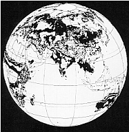 Impact Analysis by IMAGE 2.0 Model. Change in potential natural vegetation by climate change between 1990 and 2100 for two scenarios: (1) baseline (assuming no policy action to mitigate climate change), and (2) CO2 stabilization at 350 ppm by 2150 (reaching 367 ppm in 2100).
Red indicates area affected by both scenarios. Green indicates area affected by the baseline scenario, but where impact is avoided under the stabilization scenario.
_______________
Lay-out, production: Martin Middelburg, studio RIVM
National Institute of Public Health and the Environment (RIVM)
P.O. Box 1
3720 BA Bilthoven, The Netherlands
Stabilizing Greenhouse Gases: Global and Regional Consequences
Joseph Alcamo, Maarten Krol, Rik Leemans
Introduction
Article 2 of the Framework Convention on Climate Change proclaims the goal of achieving "stabilization of greenhouse gas concentrations in the atmosphere that would prevent dangerous anthropogenic interference with the climate system." The purpose of this brief report is to review some of the consequences of stabilizing greenhouse gas concentrations. It is thought that this information can be used in the process of selecting international policies for complying with the objectives of the Convention. Our analysis concentrates on two stabilization scenarios in particular because they have been adopted for study by Working Group I of the IPCC, as will be explained later.
Our analysis draws on results of the IMAGE 2.0 model, an integrated model of climate change and the global environment1. Information about IMAGE 2.0 is given in Box 1.
What Will Happen If No Action Is Taken?
In order to evaluate scenarios for stabilizing greenhouse gases, a baseline is needed for comparison. Our baseline scenario uses intermediate assumptions about population and economic growth2. This scenario also assumes that no actions are taken to mitigate climate change; this allows us to estimate the possible incremental improvements that could come from stabilization versus no action. We note that this is not meant to be a "most likely" scenario.
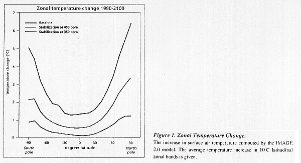
Under baseline (i.e. no action) conditions, the IMAGE 2.0 model computes that by 2100 global CO2 emissions could reach 24 Gt C/yr (within the range of IPCC emission scenarios3) and global average of CO2 concentration 777 ppm. At the same time global average surface temperature could increase by about 1.5°C in the tropics and around 3 to 5°C in the high latitude regions (Figure 1).
Box 1.
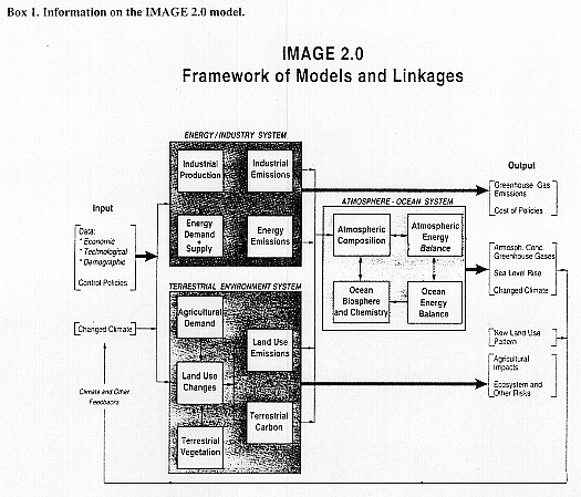
The IMAGE 2.0 model is a multi-disciplinary, integrated model designed to simulate the dynamics of the global society-biosphere-climate system. The objectives of the model are to investigate linkages and feedbacks in the system, and to evaluate consequences of climate policies. Dynamic calculations are performed from year 1970 to 2100, with a spatial scale ranging from grid (0.50 x 0.50 latitude-longitude) to world regional level, depending on the sub-model.
The model consists of three fully linked subsystems: Energy-Industry, Terrestrial Environment, and Atmosphere-Ocean. The Energy-Industry models compute the emissions of greenhouse gases in 13 world regions as a function of energy consumption and industrial production. End-use energy consumption is computed from various economic/demographic driving forces. The Terrestrial Environment models simulate the changes in global land cover on a grid-scale based on climatic and economic factors, and the flux of carbon dioxide and other greenhouse gases between the biosphere and the atmosphere. The Atmosphere-Ocean models compute the buildup of greenhouse gases in the atmosphere and the resulting zonal-average temperature and precipitation patterns.
The fully linked model has been tested against data from 1970 to 1990, and after calibration can reproduce the following observed trends: regional energy consumption and energy-related emissions, terrestrial flux of carbon dioxide and emissions of greenhouse gases, concentrations of greenhouse gases in the atmosphere, and transformation of land cover. The model can also simulate current zonal average surface and vertical temperatures.
For further information consult: Alcamo, J. (Editor). 1994. IMAGE 2.0: Integrated Modeling of Global Climate Change. Kluwer Academic Publishers, Dordrecht, 318 pp. Also published as Special Issue of Water, Air and Soil Pollution, 1992. Volume 76. Nos 1-2.
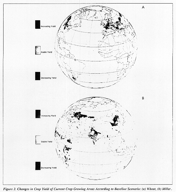
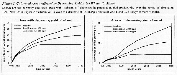
Figure 2. Changes in Crop Yield of Current Crop Growing Areas According to Baseline Scenario: (a) Wheat, (b) Millet.
Shown are "substantial" decreases or increases in the potential rainfed productivity of wheat and millet over the period of the simulation, 1990 to 2100. Substantial is defined as follows:
- For wheat -- Substantial is taken as an increase or decrease of 0.5 t/ha/yr or more. This amounts to a roughly 10% change in the current level of potential rainfed productivity in current wheat-growing areas (5 t/ha/yr). For comparison, the current net yield of wheat is substantially lower -- 2.6 t/ha/yr, globally averaged. (Agrostat PC, FAO, Rome. Computerized Information Series no. 1, October 1992). Note that impacts on only current wheat growing areas are shown. New areas might become productive for wheat under climate change. This is of course a very limited definition of threat to wheat growing areas, but does not indicate where there is increased risk to production in current areas.
- For millet -- Substantial is taken as an increase or decrease of 0.25 t/ha/yr or more. This threshold is set lower than wheat because millet is grown more often than wheat by subsistence farmers who obtain low net yields. Indeed the current net yield of millet (0.8 t/ha/yr globally averaged, FAO, 1992, op cit.) is substantially lower than that of wheat. Hence, a smaller charge in potential productivity for millet is of importance.
It should be noted that these calculations do not take into account the possible CO2 fertilization effect which could increase future yield estimates.
Such changes to temperature and precipitation could lead to a variety of impacts. We focus on three in this paper -- changes in crop productivity, disturbance of natural vegetation patterns, and sea level rise. These were selected because they are related to risks to food production, ecosystems, and economic development, which are the three impacts specifically mentioned in Article 2 of the Convention.
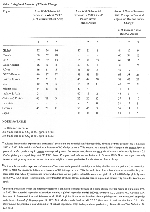
Crop Productivity. As a result of baseline changes in climate (both temperature and precipitation), large portions of currently cultivated areas could experience reductions in crop yields. As one example, the potential rainfed productivity of wheat could be substantially decreased in 26% of current wheat growing areas between the years 1990 and 2100 (Figures 2a and 3a). During the same period, millet productivity could be substantially reduced in 33% of current millet growing areas (Figures 2b and 3b). On the other hand, potential yield may increase in other areas, although this will not necessarily compensate for the disruption in yield elsewhere. The main areas affected would be current wheat growing areas in China, Western Europe, and parts of North America; and millet growing areas of Africa, the Middle East, India, and China (Figure 2).
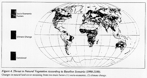
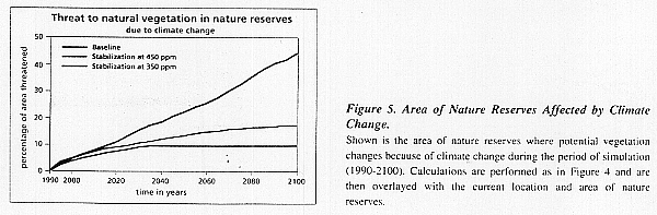
Natural vegetation. IMAGE 2.0 calculates global potential vegetation patterns by determining the occurrence of different plant types such as needle and broadleaved trees, shrubs and grasses. Each plant type has it typical distribution as a response to local climate and soil characteristics. Using this approach it was estimated that baseline change in temperature and precipitation would change the potential vegetation in 42% of the world's land area by the year 2100 (Figure 4), and in 44% of its current nature reserve areas (Table 1). Consequently, the current natural vegetation in these areas will not be well adapted to these changed climate conditions. Changes of vegetation as such a large scale could lead to severe disruption of natural vegetation succession, the main process through which vegetation can respond and adapt to new conditions. These changes will therefore impact strongly on local and regional diversity.
Climate is not the only factor that will threaten natural vegetation patterns, and thus biodiversity. Another major factor will be the expansion of agricultural land stemming from population and economic growth (which will occur despite the more intensive use of current agricultural land). This is taken into account by IMAGE 2.0 in all scenarios (Figure 4). According to the baseline scenario, 23% of the world's current nature reserve areas may be threatened by agricultural expansion between 1990 and 2100 (Figure 4). Also according to baseline calculations, 12% of
Figure 4. Threat to Natural Vegetation According to Baseline Scenario (1990-2100).
Changes in natural land cover stemming from two main factors (1) socio-economic, (2) climate change.
Socio-economic refers to current areas of natural vegetation that may be used for new agricultural land or fuelwood to satisfy the future food and fuel demands of the baseline scenario. These agricultural demand and land cover calculations are described in: (i) Alcamo, J., van den Born, G.J., Bouwman, A.F., de Haan, B., Klein Goldewijk, K., Klepper, O., Leemans, R., Olivier, J.A., de Vries, B., van der Woerd, H. and van den Wijngaard, R., 1994. Modeling the global society-biosphere-climate system, Part 2: computed scenarios. Water, Air and Soil Pollution, 76: 37-78, and (ii) Zuidema, G., van den Born, G.J., Alcamo, J. and Kreileman, G.J.J., 1994. Simulating changes in global land cover as affected by economic and climatic factors. Water, Air and Soil Pollution, 76: 163-198.
Climate change refers to areas in which the potential vegetation is estimated to change because of climate change. The potential vegetation calculations employ a global vegetation model, "BIOME", described in: Prentice, I.C., Cramer, W., Harrison, S.P., Leemans, R., Monserud, R.A., and Solomon, A.M., 1992. A global biome model based on plant physiology and dominance, soil properties and climate. Journal of Biogeography. 19: 117-134. The model BIOME is embedded in IMAGE 2.0 as described in: Leemans, R. and van den Born, G.J., 1994. Determining the potential global distribution of natural vegetation, crops and agricultural productivity. Water, Air and Soil Pollution. 76: 133-161.
the world's nature reserve areas may be threatened by both climate change and agricultural expansion during this period. This includes large areas of Africa and Asia. The main point is that there is a close connection between climate change, world food production, land use, and the world's natural vegetation cover and its level of biodiversity. Therefore policies in these areas should be closely coordinated.
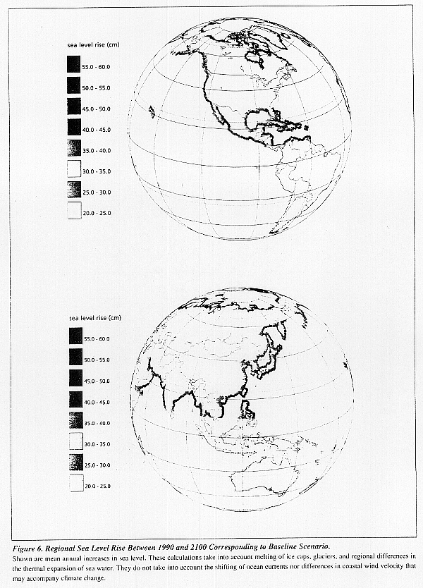
Sea Level Rise. Another consequence of not acting to mitigate climate change will be sea level
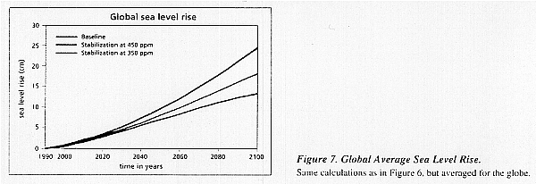
rise due to melting of glaciers and ice caps, and thermal expansion of sea water. By year 2100 sea level is computed to be 20 to 60 cm higher than in 1990, depending on location (Figure 6). Much of South Asia's coastline may experience a sea level rise of between 25 to 30 cm. Island states in the Caribbean could experience a sea level rise of the same magnitude, and those in the South Pacific between 20 to 25 cm (Figure 6).
What Stabilization Scenarios Are Considered?
One way to mitigate climate change would be to stabilize the levels of CO2 and other greenhouse gases in the atmosphere. Results from the IMAGE 2.0 model show that this could be an effective approach, depending on the target level and date of stabilization. In this paper we examine two stabilization scenarios --
- CO2 stabilized at 350 ppm in 2150 (reaching 367 ppm in 2100).
- CO2 stabilized at 450 ppm in 2100.
These scenarios are of interest from the policy standpoint because CO2 would stabilize at about its current level (around 356 ppm), or moderately above this level. These scenarios were also part of an international modeling exercise sponsored by Working Group I of the IPCC4. For both scenarios, the atmospheric levels of CO2 are assumed to follow a smooth pathway from 1990 to their future target date and concentration. Other greenhouse gases are also assumed to stabilize within this time frame5.
How Effective Are the Stabilization Scenarios?
Because of the unavoidable uncertainties of these model estimates, it is more informative to examine the relative differences between the baseline and stabilization scenarios (Figures 1, 3, 5, 7, 8 and Table 1) rather than their exact numbers. The stabilization /scenarios have the following effects:
- Regional temperature increases are substantially smaller than in the baseline scenario.
- The crop and natural vegetation areas are affected by climate change do not appreciably increase after 2100, whereas they do in the baseline scenario.
- The total amount of area affected by climate change is significantly lower than n the baseline scenario.
- Sea level continues to rise beyond 2100 despite stabilization (it also does this in the baseline scenario). This is because of the momentum of the coupled atmosphere-ocean-climate system.
- However, the rate of sea level rise is much lower than in the baseline scenario.
These results show that the stabilization scenarios have an overall lower negative impact than the baseline. However, they also show that they are not "risk-free". Impacts still occur because it takes several decades to stabilize greenhouse gases in the atmosphere, and in the meantime climate change occurs. To further reduce these impacts it would be necessary to adopt more stringent stabilization targets.
With What Emission Levels Can We Achieve the Stabilization Scenarios?
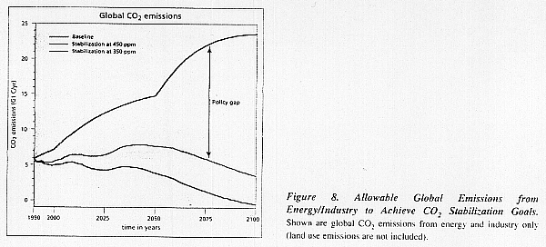
A key question is how to achieve the stabilization of CO2 and other greenhouse gases in the atmosphere. specifically, what level of emissions would be allowed from the world's energy and industrial system? After accounting for the uptake of CO2 by vegetation and the ocean, the allowable emission have been estimated by several global models as part of an IPCC Working Group I exercise6. Results from the IMAGE 2.0 model are shown in Figure 8, and are consistent with results from other models7:
- In order to stabilize CO2 levels by 2150 at 350 ppm, it will be necessary to immediately stabilize and then sharply reduce global energy/industrial emissions towards the end of the 21st century.
- For the alternative scenario of stabilizing CO2 at 450 ppm by 2100, global energy/industrial emissions will be allowed to increase slightly above current levels, and then must be significantly reduced after the middle of the next century.
Put another way, large increases in emissions would be unacceptable at any time for either scenario. This is an important point because the allowable global emissions for stabilizing CO2 and other greenhouse gases are far lower than baseline emissions (Figure 8). In the absence of policy measures, emissions are expected to sharply increase along with economic development in developing countries8. Hence there exists a large "policy gap" between the allowable emissions for stabilizing greenhouse gases, and the emissions that will occur if no action is taken. This gap is 7 to 12 Gt C/yr in 2050 and 20 to 24 Gt C/yr in 2100 (for comparison, present energy/industry emissions are about 5.5 Gt C/yr).
It should be noted that allowable emissions depend on the level and pathway of the stabilization scenario. therefore scenarios different from those presented in this report will lead to different allowable emissions.
The last issue to be raised in this report is whether emission strategies can be found to achieve the stabilization scenarios. It is possible that some proposed global energy scenarios, for example from Johannson, et al.9, Shell10, or Working Group II of the IPCC11, produce emissions low enough to achieve the stabilization scenarios. This is a key unresolved issue that needs to be clarified by the research community and reported to policymakers12.
Summing Up
This brief report highlights some of the consequences of two scenarios for stabilizing greenhouse
gases: (i) CO2 stabilized at 350 ppm in 2150 (367 ppm by 2100), (ii) CO2 stabilized at 450 ppm in 2100. Among its main findings:
- To achieve these stabilization targets, emissions are not allowed to substantially increase at any time, and eventually they must be significantly reduced.
- Because of the current upward trend in global emissions, there is a large policy gap between the allowable emissions for stabilizing greenhouse gases, and the emissions that will occur if no action is taken.
- Stabilization scenarios lead to much lower impacts on crop productivity, natural vegetation, and sea level rise as compared to the baseline case.
- Although the stabilization scenarios show lower impacts than a baseline, they are not "risk-free". Some impacts do occur, and to further reduce these impacts would require more stringent stabilization targets.
- With regards to threats to natural vegetation and biodiversity, there is a strong need to coordinate policies that address climate change, world food production, and land use.
Acknowledgements
The IMAGE Project is supported by the Netherlands Ministry of Housing, Spatial Planning and Environment (VROM), and the Netherlands National Program on Global Air Pollution and Climate Change (NRP). Authors are grateful to M. Berk, B. Lübkert-Alcamo, B. Metz, L. Meyer, and R. Swart for reviewing this manuscript. However the conclusions present in this report reflect only the views of the authors and not necessarily those of VROM, NRP, or the reviewers.
Endnotes
1 The IMAGE 2.0 model used for calculations in this report is fully documented in Alcamo, J. (Editor), 1994a. IMAGE 2.0: Integrated Modeling of Global Climate Change. Kluwer Academic Publishers, Dordrecht. Also published as Special Issue of Water, Air and Soil Pollution, 1994. Volume 76, Nos 1-2.
2 The baseline scenario is based on the Conventional Wisdom scenario documented in: Alcamo, J., van den Born, G.J., Bouwman, A.F., de Haan, B., Klein Goldewijk, K., Klepper, O., Leemans, R., Olivier, J.A., de Vries, B., van der Woerd, H. and van den Wijngaard, R., 1994b. Modeling the global society-biosphere-climate system. Part 2: computed scenarios. Water, Air and Soil Pollution. 76: 37-78. This scenario takes population and economic growth assumptions from the intermediate emissions scenario (IS92a) of the IPCC(1992). The population assumptions correspond to median estimates of the U.N. Further assumptions of the Conventional Wisdom scenario are given in Alcamo, et al., Ibid.
3 Leggett, J., Pepper, W.J., and Swart, R.J., 1992. Emission scenarios for the IPCC: an update , in Houghton, J.T., Callander, B.A., and S.K. Varney (eds) Climate Change 1992: Supplement to the IPCC 1990 Assessment. Cambridge University Press, Cambridge, pp. 71-95.
4 Enting, I.G., Wigley, T.M.L., and Heimann, M., 1994. Future emissions and concentrations of carbon dioxide. Technical Paper No. 31., CSIRO. Australian Division of Atmospheric Research, Mordialloc, Australia.
5 The IPCC Working Group I exercise on CO2 stabilization (Enting et al., 1994, op cit.) did not specify the trend of non-CO2 gases. Therefore, we make the following assumptions: (i) CFC emissions are assumed to be phased out according to international agreements as interpreted in the intermediate IPCC emission scenarios (Leggett, 1992, op cit.); (ii) the trends of other greenhouse gas concentrations (pX) resemble that of CO2 gas concentrations:
pX(t) - pX(1990) pCO2(t) - pCO2(1990) pX(1990) - pX(1900 = pCO2(1990) - pCO2(1900)
6 For these calculations it was assumed that sinks of greenhouse gases would not be artificially enhanced by large geoengineering projects such as pumping CO2 to low levels of the ocean. also, it was assumed that land use emissions would not be reduced.
7 Enting, et al., 1994, op cit.
8 See, for example, Conventional Wisdom scenario of IMAGE 2.0, Alcamo, et al., 1994b, op cit., or IPCC reference scenarios in Leggett, et al., 1992, op cit.
9 Johannson, T., Kelly, H., Reddy, A. and Williams, R. (eds), 1993. Renewable Energy, Island Press, Washington.
10 Kassler, P., 1994. Energy for development. Selected paper, Shell International Petroleum Company, Shell Centre, London.
11 Ishitani, H. and Johansson, T., 1995. Energy supply mitigation options. In: R.T. Watson and R. Moss (Editors), IPCC Working Group II: Impacts, Adaptation, and Mitigation. Cambridge University Press, Cambridge, (in review).
12 One of many important questions regarding these scenarios is whether there will be adequate land to provide the biofuels specified in these scenarios. Calculations with the IMAGE 2.0 model indicate that there could be spatial limitations in some regions (Alcamo, et al., 1994b, op. cit.)
[SEDAC] [TOP]
Sources
Parson, E.A. and K. Fisher-Vanden, Searching for Integrated Assessment: A Preliminary Investigation of Methods, Models, and Projects in the Integrated Assessment of Global Climatic Change. Consortium for International Earth Science Information Network (CIESIN). University Center, Mich. 1995.Suggested Citation
Consortium for International Earth Science Information Network (CIESIN). 1995. Thematic Guide to Integrated Assessment Modeling of Climate Change [online]. University Center, Mich.CIESIN URL: http://sedac.ciesin.org/mva/iamcc.tg/TGHP.html