
Home Page (MVA) > Integrated Assessment Models (IAMs) and Resources > IAMs Thematic Guide

MODELING THE GLOBAL SOCIETY-BIOSPHERE-CLIMATE SYSTEM: PART 1: MODEL DESCRIPTION AND TESTING
J. Alcamo, G.J.J. Kreileman, M.S. Krol, G. Zuidema
RIVM (National Institute of Public Health and Environmental Protection)
P.O Box 1
3720 BA Bilthoven, The Netherlands
Abstract
This paper describes the IMAGE 2.0 model, a multi-disciplinary, integrated model designed to simulate the dynamics of the global society-biosphere-climate system. The objectives of the model are to investigate linkages and feedbacks in the system, and to evaluate consequences of climate policies. Dynamic calculations are performed to year 2100, with a spatial scale ranging from grid (0.5 degree x 0.5 degree latitude-longitude) to world regional level, depending on the sub-model. The model consists of three fully linked sub-systems: Energy-Industry, Terrestrial Environment, and Atmosphere-Ocean. The Energy-Industry models compute the emissions of greenhouse gases in 13 world regions as a function of energy consumption and industrial production. End use energy consumption is computed from various economic/demographic driving forces. The Terrestrial Environment models simulate the changes in global land cover on a grid-scale based on climatic and economic factors, and the flux of CO2 and other greenhouse gases from the biosphere to the atmosphere. The Atmosphere-Ocean models compute the buildup of greenhouse gases in the atmosphere and the resulting zonal-average temperature and precipitation patterns. The fully linked model has been tested against data from 1970 to 1990, and after calibration can reproduce the following observed trends: regional energy consumption and energy-related emissions, terrestrial flux of CO2 and emissions of greenhouse gases, concentrations of greenhouse gases in the atmosphere, and transformation of land cover. The model can also simulate long term zonal average surface and vertical temperatures. Keywords: integrated modeling, integrated assessment, greenhouse gas emissions, global change, climate change, land cover change, C cycle.
1. Introduction
Scientific and policy questions about the global system of society, biosphere and climate are by nature multi-disciplinary, and have local, regional and global aspects. Nevertheless, most global change research focuses on either a single aspect or spatial scale of the system. The objective of the IMAGE 2.0 model described in this paper is to fill in some multi-disciplinary gaps in global change research by providing a disciplinary and geographic overview of the society-biosphere-climate system. It is our belief that this approach can provide new scientific information about the relative importance of linkages/feedbacks in the society-biosphere-climate system, and new policy information linking human activity with its consequences on the global biosphere and climate. The purpose of this paper is to summarize the development and testing of the model, emphasizing its scientific foundation; a companion paper (Alcamo et al., 1994 ) presents some preliminary applications of the model.Earlier versions of IMAGE (Integrated Model to Assess the Greenhouse Effect) are described in Rotmans (1990) and Rotmans et al. (1990), and are part of the ESCAPE framework presented in CEC (1992). The IMAGE 1.0 model proposed a global-average integrated structure for climate change issues by combining (1) an energy-model for greenhouse gas emissions, (2) a global C cycle model and (3) highly parameterized mathematical expressions for global radiative forcing, atmospheric temperature response, and sea level rise (Rotmans, 1990). The global-average calculations of IMAGE 1.0 were useful for evaluating policies at both the Dutch national level and international level (e.g. IPCC, 1990). Following this work, the developers of IMAGE 1.0 contributed to the ESCAPE framework, which combined parameterized global-average climate calculations with grid-based impact calculations for Europe (CEC, 1992). As part of the ESCAPE framework, an innovative approach was taken to estimate emissions from energy (CEC, 1992) and land use (Bouwman et al., 1992 ) for world regions. The IMAGE 2.0 model contains elements of these two submodels together with several other new submodels.
In comparison to previous integrated models, IMAGE 2.0 covers not only the entire globe, but also performs many calculations on a global grid (0.5 degree x 0.5 degree latitude-longitude); this spatial resolution increases model testability against measurements, allows an improved representation of feedbacks, and provides more detailed information for climate impact analysis (discussed further in Sec. 1.2). Moreover, the submodels of IMAGE 2.0 are in general more process-oriented and contain fewer global parameterizations than previous models, which enhances the scientific credibility of calculations (NRP, 1993). Of course, these developments also add greatly to the computational and data handling tasks of the model.
1.1 Objectives of the Model
The scientific goals of the IMAGE 2.0 model are:- To provide insight into the relative importance of different linkages in the society-biosphere-climate system;
- To investigate the relative strengths of different feedbacks in this system;
- To estimate the most important sources of uncertainty in such a linked system and
- To help identify gaps in knowledge about the system in order to help set the agenda for climate change research.
- To link important scientific and policy aspects of global climate change in a geographically-explicit manner in order to assist decision making;
- To provide a dynamic and long-term (50 to 100 years) perspective about the consequences of climate change;
- To provide insight into the cross-linkages in the system and the side effects of various policy measures;
- To investigate the influence of economic trends and technological development on climate change and its impacts and
- To provide a quantitative basis for analyzing the costs and benefits of various measures (including preventative and adaptive measures) to address climate change.
1.2 Model Sub-systems
The model consists of three fully linked sub-systems of models (Figure 1):- The Energy-Industry System;
- The Terrestrial Environment System and
- The Atmosphere-Ocean System.
The Terrestrial Environment models simulate the changes in global land cover on a grid-scale based on climatic and economic factors. The role of land cover and other factors are then taken into account to compute the flux of CO2 and other greenhouse gases from the biosphere to the atmosphere. This sub-system includes the following submodels: Agricultural Demand, Terrestrial Vegetation, Land Cover, Terrestrial Carbon, and Land Use Emissions.
The Atmosphere-Ocean models compute the buildup of greenhouse gases in the atmosphere and the resulting zonal-average temperature and precipitation patterns. The following sub-models are included: Atmospheric Composition, Zonal Atmospheric Climate, Oceanic Climate, and Oceanic Biosphere/Chemistry.
One of the main scientific contributions of IMAGE 2 is its representation of many of the important feedbacks and linkages between models in these sub-systems, and between sub-systems. The sub-systems are described in Sections 2 to 4 of this paper.
1.3 Temporal and Spatial Scales
In order to provide a long-term perspective about the consequences of climate change, the model's time horizon extends to year 2100. The time steps of different submodels vary, depending on their mathematical and computational requirements, but typically vary from one day to five years.Another goal of the model is to provide as much information as possible on a grid of 0.5 degree latitude by 0.5 degree longitude. This is because nearly all potential impacts of climate change (e.g., impacts on ecosystems, agriculture, and coastal flooding) have a strong spatial variability. Moreover, land use-related greenhouse gas emissions (e.g., N2O from soils or NH4 from agricultural activities) greatly depend on "local" environmental conditions and human activity. In addition, climate feedbacks, such as the effect of temperature on soil respiration or the effect of changing CO2 levels on plant productivity also vary substantially from location to location. There are two additional reasons for computing grid-scale information. First, policy makers are interested in regional/national policies to address climate change. Indeed most climate policies are location-specific (e.g. sequestering carbon in forest plantations, or reducing N2O by modifying agricultural practices). Second, grid-scale information makes model calculations more testable against observations as compared to more aggregated models.
Nevertheless, we are unable at this time to provide grid-scale calculations for all components of climate change. In particular, this is infeasible for economic calculations because of the difficulty in specifying economic/demographic factors (e.g. trade relationships, technological development, and similar data) on a country- or sub-country scale for the entire world over the long time horizon of the model. As an intermediate step, economic calculations are performed for 13 world regions (Figure 2), which follows common practice in global economic studies. The criterium for grouping countries together in a particular region is mainly economic similarity, and our grouping conforms somewhat to that used by the IPCC, OECD, U.N., and other international organizations. A list of countries comprising the world regions is given in Appendix 1. (We should note that these organizations themselves do not have a common method for aggregating countries.) However, the IMAGE 2.0 model has the additional requirement that countries within a region be adjacent or nearby because of the model's approach to global land cover simulation (see below).
1.4 A Note on Modeling Approach
Since the IMAGE 2.0 model is based on large global data sets and poorly-understood global processes, it is unavoidable that many parameters are ill-defined and have large degrees of freedom. With this in mind, our basic approach is to propose submodels that have comparable level of process detail, and to adjust a limited number of parameters with greatest degree of freedom to obtain model calculations in reasonable agreement with 1970-90 data. We selected the period 1970-90 because of data availability, although we intend to test the model against data from a longer historical period. We first tested individual submodels and adjusted their parameters, then linked and tested the three sub-systems of models, and finally the fully linked model. In the following paragraphs we identify the key parameters that can be adjusted in each of the submodels. Results of the fully linked model are presented in Section 5.Of course, this procedure does not ensure that adjusted parameters and other inputs will be correct for scenario analysis under changed economic and environmental conditions; nevertheless, it does indicate the adequacy of the model in explaining global changes that occurred during the 1970-90 period, such as the increase in energy-related emissions, estimated changes in deforestation rate and terrestrial carbon fluxes, and the build-up of various greenhouse gases in the atmosphere.
2. Energy-Industry System of Models
The objective of the Energy-Industry system of models is to compute the emissions of greenhouse gases from world regions as a function of energy consumption and industrial production. The models are designed especially for investigating the effectiveness of improved energy efficiency and technological development on future emissions in each region, and can be used to assess the consequences of different policies and socio-economic trends on future emissions.2.1 Energy Economy Model
The Energy Economy model divides the energy economy of each world region (Figure 2) into five energy sectors (Table 1) and computes the demand for end use "heat" and "electricity" in each of these sectors (six energy carriers are included, Table 1). Such an end use approach makes it easier to assess the potential of energy conservation measures in reducing overall energy consumption and, in turn, in reducing greenhouse emissions. Details of the models are given in de Vries et al. (1994).
End Use Energy Carriers and Sectors in Energy Economy ModelEnergy
| Carriers | Energy Sector | Corresponding |
| Coal | Industry | Activity Level Value-added Industrial production |
| Gas | ||
| Oil | Transportation | Number of vehicles |
| Fuelwood | Residential | Personal expenditures |
| Other Biomass | Commercial | Value-added commercial services |
| Electricity | Other | GNP |
The end use heat and electricity is computed from elasticity functions that relate "activity levels" of each sector (Table 1) with end use energy consumption. Elasticity coefficients are derived for each world region with data from 1970 to 1990. The computation of end use energy also includes an energy conservation function which relates energy prices from 1970 to 1990 with the motivation for energy conservation during that period. The main adjustable variables in the model are the parameters of this energy conservation function, and the above elasticity coefficients, the main driving forces in the model are regional changes in population and GNP.
The computed end use electricity in each sector is converted into a required power plant capacity by taking into account an average power conversion rate for each region. The final step of calculations is to compute primary consumption of energy by specifying a region-specific fuel mix to deliver the end use heat in each sector, and to fulfill the required power plant capacity.
2.2 Energy Emissions Model
The Energy Emissions model applies emission coefficients to the energy consumed in each energy sector to compute the amount of CO2, CH4, N2O, and other greenhouse gases released from each region (Table 2). These sector-specific emission coefficients are obtained from the literature, but adjusted within their known range until good agreement is obtained between model calculations and data for global and regional emissions in 1990. In addition, the model takes into account emissions of CH4 that are related to fuel transportation/transformation such as CH4 leakage from natural gas pipelines. Because the Energy Emissions model is linked to the Energy Economy model, the model user can investigate emission control strategies related to the energy system; e.g. the feasibility of reducing emissions by altering the fuel mix in a sector, or by improving the efficiency of different technologies used to provide energy. In addition, control strategies of non-CO2 gases can be investigated by prescribing reductions of gases due to abatement technologies.
Main sources of greenhouse gases accounted for in the IMAGE 2.0 model.
| Source Greenhouse Gas | IMAGE 2.0 | Submodel** |
| Fuel combustion in end use sectors (Table 1) | CH,CO,CO,NO,NO,VOC | EE |
| Energy conversion, transformation, and transportation | CH,CO,CO,NO,NO,VOC | EE |
| Industrial processes | NO,VOC, halocarbons | IE |
| Cement manufacturing | CO | IE |
| Wetland rice fields | CH | LUE |
| Natural wetlands | CH | LUE |
| Landfills | CH | LUE |
| Animal enteric fermentation | CH | LUE |
| Animal waste | CH,NO | LUE |
| Natural soils | NO | LUE |
| Fertilized soils | NO | LUE |
| Aquatic sources | CH,NO | LUE |
| Biomass burning (Deforestation, agricultural waste burning, savanna burning) | CH*,CO*,CO*,NO*,NO*,VOC* | LUE,TC |
| Soil Respiration | CO* | TC* |
Emissions calculated on grid-scale. Regional totals calculated for other sources.
** EE = Energy Emissions model, IE = Industrial Emissions model, LUE = Land Use Emissions model, TC = Terrestrial Carbon model.
2.3 Industrial Production and Industrial Emissions Models
The Industrial Production and Emissions models are used to compute emissions of greenhouse gases or their precursors that are not directly associated with energy combustion. (Emissions coming from the combustion of fuel by industry are taken into account in the "Industry" sector of the Energy Emissions model described above.) Examples of these emissions are: halocarbon emissions from refrigerators and industrial products, CO2 from the cement industry, and VOCs from chemical manufacturing. Because emissions are related to the level of industrial activity, future activity is computed by the Industrial Production model which uses a simple indexing method to compute future industrial output in different regions.2.4 Linkages of Energy/Industry with the Rest of IMAGE 2.0
In the Atmospheric Composition model (see below), emissions from the Energy-Industry sub-system of IMAGE 2.0 are added to emissions of CO2 and other greenhouse gases coming from the terrestrial biosphere; the model then computes the resulting build-up of greenhouse gases in the atmosphere. The Energy-Industry sub-system is also linked to other parts of IMAGE 2.0 via the demand for fuelwood; this demand is computed in the Energy Economy model and then used by the Land Cover model (described below) to compute new deforested areas. (However, only part of the fuelwood demand is assumed to lead to deforestation). The Terrestrial Carbon model (also described below) computes the change in terrestrial carbon flux owing to fuelwood extraction. Biofuel demands computed by the Energy Economy model are also taken into account in the Land Cover model as an additional demand for land competing with the demand for land to satisfy food demand. This linkage allows the model to comprehensively evaluate the effect of using biofuels on greenhouse gas emissions. No feedbacks of global change on energy use are taken into account.3. Terrestrial Environment System of Models
The aim of the Terrestrial Environment system of models is to simulate global land cover on a grid-basis, and its effect on greenhouse gas emissions and carbon flux from the biosphere to the atmosphere. This set of models can be used to evaluate the effectiveness of land use policies for controlling the build-up of greenhouse gases including changed agricultural practices or sequestration of carbon in forest plantations. They can also be used to evaluate the impact of climate change on global ecosystems and agriculture.3.1 Agricultural Demand Model
Transformations of global land cover are strongly related to changing land use for agricultural products, which require croplands, pasture land, rangelands, and managed forests. The purpose of the Agricultural Demand model is to estimate the societal demands for agricultural products that lead to significant land use demand. These calculations are performed for the same 13 world regions as used in Energy-Industry system (Figure 2) and using the same main driving factors (population, GNP), and are detailed in Zuidema et al. (1994).The Agricultural Demand model begins by calculating the per capita human consumption for different crops and meat products based on an assumed elasticity relationship between consumption and per capita income. These elasticity coefficients are estimated from 1970-90 data of the U.N. Food and Agriculture Organization, and are the main adjustable parameters in the model. Total human (as opposed to animal) demands for these products are then computed for a given income and population scenario. The same procedure is followed to compute the total demand for meat in a region.
The demand for meat is converted into a required number of livestock, and feed requirements of animals are divided into "concentrates" from crops and crop residues, and "roughage" from rangeland and pasture land. The demand for animal feed concentrates adds to the demand for crops computed above for the human population. These two factors together lead to the total regional demand for crops and other non-meat agricultural products. This demand is converted into actual cropland demand in each region by taking into account export and import from each region. The demand for animal feed roughage is converted into a demand for grassland by taking into account the average amount of rangeland required per animal.
World timber production and trade is currently not included in the model, but demand for fuelwood is computed in the Energy Economy model (described above). Similarly, world food trade is presently prescribed rather than computed by the model, although it is planned to include a simple trade model in the next version.
3.2 Terrestrial Vegetation Model
Global land cover transformations depend not only on demand for land, but also on its potential. The purpose of this model is to compute "potential land cover", i.e. the potential vegetation and potential crop productivity in a global grid for a given climate and soil. This model is described in Leemans and van den Born (1994). Calculations are performed on a spatial grid of 0.5 degree latitude by 0.5 degree longitude.Two different models make up the Terrestrial Vegetation model:
A modified version of the BIOME model (Prentice et al., 1992) is used to compute potential vegetation. The basic idea of this model is that global vegetation patterns can be derived by conglomerations of plant functional types, each having definable environmental constraints. If environmental conditions can be described at a particular site (e.g., mean coldest-month temperature, and effective temperature sums), then the types of plants which occur can also be predicted. Different plant types are then aggregated into the land cover categories of IMAGE 2.0 (described below under Land Cover model.) This aggregation procedure is the main way to calibrate the model to current vegetation. In the present version of the model the use of the BIOME model is limited. Land cover is initialized according to Olson et al. (1985). The BIOME potential vegetation is allocated to a cell only when it is abandoned agricultural land. Full use of the BIOME model will be made in the next version of the IMAGE 2 model.
The FAO Crop Suitability model (FAO, 1978) computes the potential productivity of eight crop classes on a global grid. These are the "constraint-free rain-fed yields" based exclusively on local climatic conditions. First, the potential growing period of a particular crop is estimated from local temperature and moisture conditions. If the growing period is found to be sufficient for a particular crop, then its potential productivity is estimated from a simple relationship between the crop's rate of photosynthesis and local climatic variables.
The climate-related yields computed by the FAO model are adjusted for grid-specific soil conditions by a "soil factor" (ranging from 0.1 to 1.0) which takes into account three soil quality indicators: (i) nutrient retention and availability, (ii) level of salinity, alkalinization, and toxicity, (iii) and rooting conditions for plants (related to soil texture), all three assumed to be constant in time.
3.3 Land Cover Model
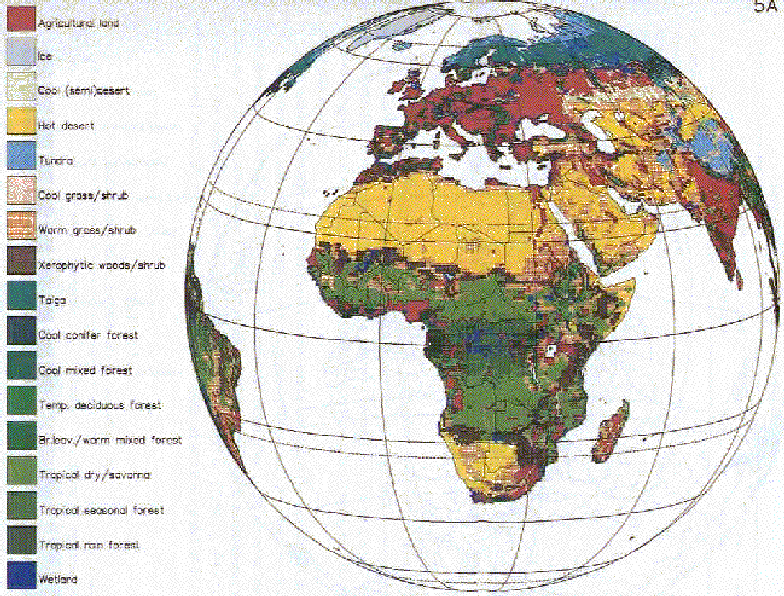
This model simulates land cover transformations on a global grid by reconciling the regional demand for land use with the "local" potential for land. The model is described in detail in Zuidema et al. (1994). The two main inputs to the model are (1) regional demands for cropland and rangeland (from the Agricultural Demand model) and fuelwood demand (from the Energy Economy model), and (2) "local" potential for land (from the Terrestrial Vegetation model). Table 3 gives an overview of the factors taken into account to compute global land cover.Global land cover is divided into 17 categories (see Figure 5a) on a global grid of 0.5 degree latitude by 0.5 degree longitude; these categories are aggregated from the 51 categories in Olson's (1985) data base. We use Olson's data to initialize the model in 1970. Land use demands for different types of cropland are satisfied by a single land cover category --"agricultural land", while the demand for rangeland can be satisfied by several types of grassland, depending on what exists "locally" -- warm grassland, cool grassland and tropical dry savanna. We assume that in Africa, India plus S. Asia and East Asia, urban residential fuelwood demand leads to forest clearing and subsequently to another land cover type (Zuidema et al., 1994).
TABLE 3
Factors Included in Calculation of Land Use Demand and Land Cover Potential in Terrestrial Environment System of IMAGE 2.0 Factors For Land Use Demand Factors for Land Cover
| Use Demand | Factors for Land Cover Potential |
| Demand for 8 classes of crops | Climate-limited potential productivity of 8 classes of crops |
| Demand for 4 classes of livestock | Reduction to crop productivity due to local soil conditions |
| Demand for fuelwood | Land requirement per unit livestock |
| Land for biofuels and plantations | Climate-limited potential vegetation types (other than crops) |
The basic idea of the Land Cover model is to change gridded land cover within a "world region" until the total demands for the region are satisfied. (For this reason, countries within a region must be geographically close to one another.) In a sense the model produces pictures of future landscapes logically consistent with demand and potential. Of course, satisfying the demands of a world region by increasing agricultural production anywhere within its territory is an unsatisfactory assumption. Yet the alternative -- taking into account country-scale or grid-scale land use demands -- is infeasible at this time because of the data and analysis necessary for estimating these demands for the entire world and over a long projection period. The model takes into account several types of land conversion including many crucial to global change such as tropical deforestation arising from demand for cropland and rangeland or demand for fuelwood, or reforestation of abandoned agricultural land.
In order to satisfy the regional agricultural demand correctly, we would need to fully comprehend the basic driving forces of land cover transformations. Since these forces are in general poorly understood, our approach is to prescribe transparent, logical "rules" to match land demand with potential. These land use rules are tested to see if they can explain known transformations of land cover from 1970 to 1990. If they can explain historical changes, they can also provide some basis for simulating future land use changes. These rules, together with a "management factor" (which takes into account the effect of technology on yield per hectare), are the main adjustable variables in the model. As an example of their straightforward nature -- there are two weighted rules that guide the assignment of new agricultural areas: (1) new areas should occur adjacent, if possible, to existing agricultural land (because of availability of transport, infrastructure, and population), and (2) new areas should occur in locations of highest potential productivity. Similar sets of rules are specified to satisfy fuelwood and rangeland demand. The model is calibrated by adjusting the management factor until the computed coverage of agricultural land in each region agrees with FAO estimates (FAO, 1992).
3.4 Terrestrial Carbon Model
Because CO2 is the most important contributor to global radiative forcing, it is of particular importance to accurately estimate its global sources and sinks. Elsewhere in IMAGE 2.0, we compute the source of CO2 from fossil fuel combustion (Energy Emissions model), and its net geochemical sink in the ocean (Ocean Biosphere/Chemistry model). In the Terrestrial Carbon model we estimate the sources, sinks, and reservoirs of C in the terrestrial biosphere resulting from natural processes and human disturbances. The model is described in detail in Klein Goldewijk et al. (1994). This is a grid-scale adaption of the terrestrial part of the C cycle model proposed by Goudriaan and Ketner (1984).The model describes the CO2 flux of the biosphere by computing Net Ecosystem Productivity (NEP), i.e. the difference between CO2 assimilated by Net Primary Productivity (NPP) and CO2 released by organic decay processes. NPP is pre-defined by land cover category, but scaled to temperature and moisture availability in order to take into account a possible change in productivity if local climate changes. The initial NPP is the main adjustable parameter of the model.
To properly take into account organic decay processes, the reservoirs and fluxes of C within each land cover type are estimated. First, the C in living plant material is partitioned into different biomass components: leaves, branches, stems and roots. Next, rates of decay to non-living matter (litter, humus and charcoal) are assigned based on turnover times of the living plant materials. Last, the decay of non-living matter leads to release of CO2.
It is often assumed that C in natural ecosystems is in equilibrium with the atmosphere and thus have a NEP of zero, implying no net release of CO2 to the atmosphere. However, when land is converted from one type to another, this balance is disturbed. To compute CO2 flux due to human disturbances, we make a consistent set of assumptions regarding the fate of biomass under each type of conversion (e.g. forest to grassland, or grassland to agriculture). For instance, when a tropical forest grid cell is converted to either grassland or agricultural land, it is assumed that certain fractions of its biomass components are burned on-site, immediately releasing CO2. In addition, the remaining biomass is allocated to non-living C reservoirs which may accelerate decay processes, and the new land cover type often has a lower NPP; the sum of these changes may result in an additional long term low flux of CO2 from this location. Other land conversions are treated in a similar way, with assumptions being made about the fraction of biomass burned and the allocation of remaining biomass.
The model also takes into account various feedbacks to the biosphere including the effect of moisture availability and temperature on soil respiration, and the effect of temperature and CO2 on NPP ("CO2 fertilization"). The CO2 fertilization effect, in turn, takes into account local limitations to enhanced C uptake due to temperature, moisture availability, nutrient availability and elevation. Both global warming and the rising concentration of CO2 constantly change the equilibrium state of C in the natural ecosystem to which the actual ecosystem is approaching.
3.5 Land Use Emission Model
In this model we compute emissions of CO, CH4, NOx, N2O, and VOC stemming from different types of land use/cover (Table 2). (The flux of CO2 from the terrestrial environment is computed by the Terrestrial Carbon model described above). The Land Use Emissions model is described in Kreileman and Bouwman (1994). Land cover patterns and transformations computed by the Land Cover model are used for calculations in this submodel, together with emission coefficients and additional data. The emission coefficients are the main adjustable parameters of the model. Some of the more important processes covered by the model are:Biomass Burning (Forest, Grassland, Savanna, Agricultural waste). The clearing and burning of vegetation releases not only CO2 but other greenhouse gases as well. The emissions of CO, CH4, N2O, NOx ,and VOCs are estimated by using a fixed ratio between these compounds and emitted CO2 (as calculated by the Terrestrial Carbon model). The C release by seasonal burning of savanna and agricultural waste is assumed to be compensated for by subsequent vegetation. For these sources only the net emissions of non CO2 gases are taken into account.
Animals, Livestock. Enteric fermentation of animals is a significant source of atmospheric CH4. To obtain total regional emissions, the total number of animals in a region are computed by the Agricultural Demand model and this number is multiplied by a fixed emission factor per animal.
Natural Wetlands. Anaerobic biological processes in wetlands are estimated to be a large source of CH4. The area of wetlands is included in the land cover data base, and are multiplied by a fixed emission factor to obtain CH4 emissions.
Irrigated Rice Fields. Anaerobic decomposition in rice paddies is an important source of atmospheric CH4. The total rice-growing area is estimated by the Land Cover model described above based on regional rice demands, and this area is multiplied by a fixed emission factor to compute CH4 emissions.
Other Sources of Greenhouse Gases. Additional sources of greenhouse gases included in the model are landfills, animal waste, agricultural residue burning, and natural soils (Table 2).
3.6 Linkages within the Terrestrial Environment System
The models within the Terrestrial Environment system are linked in a straightforward way. Nevertheless, some of these linkages deserve attention since they represent important feedback processes that are not usually considered.In the grid-based part of the computations climate indices play an important role. These indices determine not only the potential vegetation at a specific location, but also the potential productivity of crops at that location, some of the main quantities in the C cycle simulation (eg. NPP) and emissions of non CO2 gases (eg. CH4 from rice paddies). The climate indices are, of course, shared by the models within the Terrestrial Environment system. In this way the changes in land cover, the changes in the terrestrial C cycle, and the changes in land cover related emissions of non CO2 gases are inherently consistent.
Another obvious link concerns the effect of changing land cover on emissions. Increasing agricultural demand can lead to expanding agricultural area and shrinking area of natural vegetation. In this way anthropogenic influences also affect the natural emissions of greenhouse gases, a feedback process that is usually not represented in emissions scenarios (IPCC, 1990; IPCC, 1992).
3.7 Linkages of the Terrestrial Environment System with the Rest of IMAGE 2.0
Emissions from the terrestrial environment are combined with emissions from the global energy system (calculated by the Energy/Industry models) and are input to the Atmosphere-Ocean models in order to compute the build-up of greenhouse gas concentrations and the resulting radiative forcing and global temperature and moisture patterns. The computed change in climate and CO2 are then fed back to the Terrestrial Environment System to calculate changes in potential vegetation, potential crop productivity, NPP , and so on.Changes in land cover are used by the Zonal Atmospheric Climate model to re-compute latitudinal-average albedo. Changes in albedo may affect the zonal energy balance.
We have already referred to the link between the Industry-Energy and Terrestrial Environment subsystems via the demand for fuelwood and biomass. The additional demand for land owing to these fuel demands are taken into account in the Land Cover model.
4. Atmosphere-Ocean System of Models
The purpose of this system of models is to compute the build-up of greenhouse gases in the atmosphere and the resulting change in global temperature and precipitation patterns. A detailed overview of this system is given in de Haan et al. (1994). The basic idea of these models is to compute transient changes in climate resulting from changes in greenhouse gas emissions, and to do it in a way that is more computationally economic than a general circulation model (GCM). This makes it feasible to dynamically link the Atmospheric-Ocean models with the Energy-Industry and Terrestrial Environment sets of models described above, and makes it possible to use the entire IMAGE 2.0 model iteratively for policy analysis.Unlike most GCMs used up to now, the model includes not only CO2, but all major greenhouse gases explicitly in its radiative scheme. Consequently the model can be used to analyze such problems as the effect of a shift in energy supply from oil to biofuels. Such a shift will reduce CO2 emissions but enhance non-CO2 emissions.
The tradeoff of using the present set of atmosphere-ocean models is a lower degree of scientific realism as compared to a GCM, in that IMAGE 2.0 parameterizes many atmospheric/oceanic processes that are explicitly described in a GCM. As an example, zonal heat circulation in IMAGE 2.0 is parameterized as a diffusion process by a few simple expressions based on observations, whereas it is usually explicitly calculated in GCMs. Furthermore, IMAGE 2.0 requires GCM results to scale down zonal average temperature and precipitation patterns to the grid level (see discussion of linkages below).
4.1 Atmospheric Composition Model
As a starting point, CO2 and other emissions as well as C sequestration computed by the Terrestrial Environment System are combined with emissions from the Industry-Energy System and are input to the Atmospheric Composition model. This model is described in Krol and van der Woerd (1994). The temporal trends of the average tropospheric concentration of the following gases are computed: CO2, CH4, N2O, CFCs and other halogenated species, O3, OH radicals, and CO. The influence of emissions of N2O and NMHCs on atmospheric composition are accounted for. Although simple, the model does explicitly describe the non-linear relationship between chemical species most relevant to radiative forcing.The calculation of CO2 takes into account the fluxes between the atmosphere, ocean and biosphere. Computation of CH4 includes anthropogenic and natural sources, and losses by deposition onto the biosphere, dispersion from the troposphere to stratosphere, and oxidation by OH radicals. Because of the importance of the OH sink, the level of OH is explicitly computed, taking into account loss through CO oxidation. Tropospheric levels of N2O and CFCs are computed using fixed atmospheric lifetimes.
To compute tropospheric O3, the model takes into account its precursors, NOx, CH4 and CO. For the lower stratosphere, the level of O3 is parameterized by the availability of free Cl and in the upper stratosphere by the levels of Cl and active N and ambient temperature. The parameterizations used for O3 and other calculations in the Atmospheric Composition model are derived from "multi one-dimensional" atmospheric chemistry models (Thompson et al., 1989).
The level of sulphate aerosol is computed in a very provisional way by scaling the current spatial distribution of sulphate aerosol to the trend of global sulphur emissions. We distinguish between the sulphate aerosol originating from anthropogenic and biogenic sources. Hence, for scenario analysis, we can in a very preliminary fashion, take into account the different trends in anthropogenic versus biogenic sulphur emissions.
4.2 Zonal Atmospheric Climate Model
In the second part of the computations, the Zonal Atmospheric Climate model uses the computed atmospheric levels of greenhouse gases and sulphate aerosol together with other data, to compute the earth's energy balance (de Haan et al ., 1994). First, the radiative forcing due to greenhouse gases (H2O, CO2, CH4, N2O, O3, CFC-11 and CFC-12) is computed using shortwave and longwave parameterizations from MacKay and Khalil (1991). Also included is the cooling effect of backscattering of solar radiation on sulphate aerosol. For radiative forcing calculations, the atmosphere is divided into 18 layers.Next, the earth's heat balance is computed in eight vertical layers and along 10 degree latitudinal bands using a set of heat balance equations for the atmosphere and surface heat exchanges with land and ocean (Peng et al., 1982). Temperature is the only prognostic variable in the model in that all processes are parameterized relative to a temperature field which depends on latitude and altitude. Horizontal heat and moisture transport is treated in a simple way by assigning constant diffusion coefficients, and vertical transport by an altitude-dependent diffusion coefficient. As noted previously, surface albedo includes the effect of changing land cover computed by the Land Cover model. Both sea-ice coverage of the oceans and snow coverage of land are parameterized to surface temperature, and cloud cover is represented as a single effective layer. The height and optical thickness of clouds are the main calibration variables in the model.
The main output of the model is annual average surface air temperatures in 10 degree latitudinal bands covering the entire globe, both land and ocean. The model also makes a crude estimate of average latitudinal precipitation rate by taking the difference between computed rates of surface evaporation and divergence of H2O.
4.3 Oceanic Climate Model
In order to accurately calculate the energy balance and CO2 level of the atmosphere, it is necessary to account for the ocean's role as an enormous sink of heat and CO2. This is done in the IMAGE 2.0 ocean models (de Haan et al., 1994). In the Oceanic Climate model, the world's oceans are divided into vertical layers of 400m thickness, and horizontal segments of 10 degree latitude, in order to link with the latitudinal bands of the Zonal Atmospheric Climate model.Advective circulation in the world's oceans is prescribed in the model based on the "conveyor belt" concept of Broeker and Peng (1982), and includes both horizontal flow, as well as upwelling and downwelling estimates. Dispersion coefficients are adjusted so that the model agrees with observed profiles of 14C and 3H. By representing the ocean's circulation patterns, the model can estimate the dispersal of heat via horizontal and vertical transport.
4.4 Ocean Biosphere/Chemistry Model
To correctly compute CO2 levels in the atmosphere it is also important to take into account the ocean's physical/chemical uptake of CO2, as well as the flux of C from oceanic phytoplankton. These processes are covered by the Ocean Biosphere/Chemistry model (de Haan et al., 1994; Klepper et al., 1993). The physical-chemical uptake of CO2 at the ocean-atmosphere interface is treated in the conventional way by taking into account temperature-dependent equilibria between atmospheric CO2 and aquatic carbonate compounds. The role of oceanic phytoplankton in releasing and assimilating CO2 is represented by non-linear equations relating nutrients, light, and temperature to phytoplankton growth. Also included is the process by which non-living organic matter sinks to lower oceanic layers, serving as a "carbon pump" of atmospheric CO2. While this carbon pump is not thought to be important now, it may play a role in future build-up of atmospheric CO2 if oceanic circulation changes. The sensitivity of the model to such changes is investigated by changing the ocean circulation in a prescribed way, see for instance de Haan et al. (1994). The Ocean Biosphere/Chemistry model and the Ocean Climate model are defined on the same grid and share the description of dispersion.The model incorporates a variety of feedbacks from the atmosphere to the oceanic environment including the effect of temperature on CO2 aqueous solubility, the effect of temperature and CO2 on phytoplankton productivity, and the effect of temperature on the recycle rate of non-living matter to phytoplankton. Many feedback processes influencing the oceanic C cycle have been identified. Feedbacks vary both in their effect on the C cycle and in their uncertainty (Klepper et al., 1993). Here only the fairly well established processes are included.
4.5 Linkages within the Atmosphere-Ocean System
Within the Atmosphere Ocean system many climate related feedbacks exist. Obviously changes at the interface of atmosphere and ocean are treated consistently in both models.Warming of the atmosphere affects atmospheric composition. Increase of temperature in the troposphere leads to higher H2O mixing ratios. This has a positive effect on the formation of OH radicals, thus enhancing the atmospheric sink for CH4 and other gases.
Increases of sea surface temperature affect not only the equilibrium concentration of dissolved C, but also the sea ice coverage. This changes the area of the open sea where gas exchange is possible. This effect is important, especially since the CO2 solubility is largest in colder waters, ie. at high latitudes, where the sea ice is located.
4.6 Linkages between the Atmosphere-Ocean System and the Rest of IMAGE 2.0
At each model time step, new computed patterns of surface air temperature and precipitation are input to the Terrestrial Environment System to calculate changes in potential vegetation, which leads to a new land cover pattern, land use emissions, and so on. Computed temperature and precipitation are also fed back to other parts of the Terrestrial Environment System, for example, to modify the rates of primary productivity in the Terrestrial Carbon model, and to modify the rate of N2O emissions computed by the Land Use Emissions model. The coupling of land cover and surface albedo has already been mentioned. At this point there is no linkage between the moisture/heat flux to the atmosphere assumed in the Zonal Atmospheric Climate model and global land cover computed by the Land Cover model, although this linkage is a high priority in the next version of IMAGE 2.Since output data from the Atmosphere-Ocean models are in the form of latitudinal averages, these data must be transformed to the global grid of IMAGE 2.0 calculations. This transformation is performed with data from the current climate data base of Leemans and Cramer (1991) and with interpolated results from a general circulation model of Manabe and Wetherald (1987).
The transformation of zonal average climate changes to grid-scale changes is, of course, a source of model uncertainty. To investigate this uncertainty we compare downscaling results using four different GCMs. Model runs were performed with identical, Business as Usual type forcing functions, while using results of climate change due to CO2 doubling from four different GCMs (GFDL, GISS, OSU, UKMO). On the time horizon of the model (1970 to 2100) differences in global quantities were small. Differences in CO2 concentrations never exceeded 15 ppmv, or 2%, differences in CH4 concentrations were limited to 0.02 ppmv (less than 1 %), global temperatures were only 0.04 degree C apart. Larger differences appeared in the areas of agricultural land (3% global, but up to 20% in specific regions) and the geographic distribution of agricultural land. Especially at higher latitudes, where the climate change signal is strongest, significant differences were found in, for instance, the total forested area and the northward shift of agricultural area.
5. Model Testing
5.1 Comparison to 1970-90 Data
The individual submodels and fully linked version of IMAGE 2.0 have been tested against measurements and other data from 1970-90. This period was selected because of the availability of data, although we plan to use data from a longer historical period for additional validation tests. In this section we briefly review results for the entire linked model. The results of individual submodels are examined in more detail in the papers quoted in sections 2,3 and 4 of this paper.For these tests it was necessary to assume or estimate the initial states of all models in 1970. Submodels with highly dynamic behaviour were initialized in 1900 in order to establish their non-equilibrium states in the year 1970. For the initialization of the Terrestrial Carbon model, it was assumed that the various reservoirs of terrestrial C were in steady state in 1900; using this steady state as an initial condition, the model was then run to 1970, using as input the historical changes in CO2 and climate. To initialize the Zonal Atmospheric Climate, Ocean Climate, and Ocean Biosphere/Chemistry models, these models were linked and run to equilibrium by setting the atmospheric concentrations of greenhouse gases constant at their estimated 1900 levels. Starting from this equilibrium state, the linked models were then run in transient mode from 1900 to 1970, using historical concentrations of CO2 and other greenhouse gases.
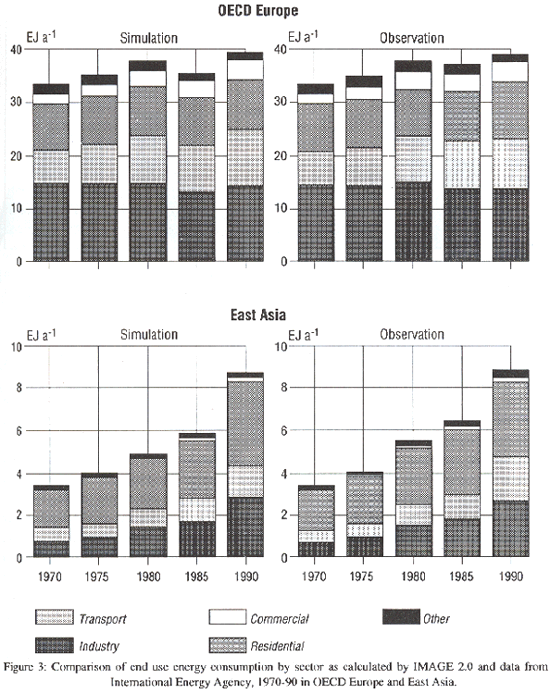
As to the results -- The Energy Economy model calculates the consumption of energy in five sectors, and these figures are quite close to official data from 1970-90 for all regions. Sample results are presented for OECD Europe and East Asia in Figure 3. The computed energy consumption differs somewhat from official data, but the model captures the slump in energy consumption in OECD Europe after 1980, and the steady rise in energy consumption in East Asia during this period. Results for other regions (de Vries et al., 1994) are similarly good. It seems that the simple economic-energy relationships contained in the Energy Economy model are adequate for reproducing recent trends.
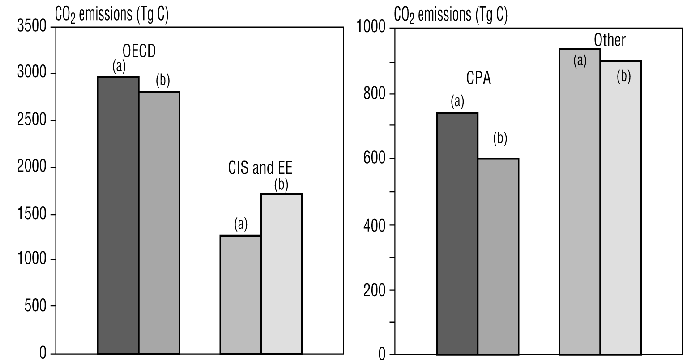
Based on the computed sectoral energy consumption and other data, the Energy-Emissions model computes energy-related emissions of greenhouse gases. Estimates from this model are within ±25% of 1990 data from the four IPCC world regions ( Figure 4). This mainly shows that the emission categories and coefficients in the model have been correctly selected and calibrated, at least for 1990.
The Land Cover model computes global changes in land cover in the period 1970 to 1990 by taking into account actual demand for agricultural commodities together with estimated potential crop productivity and vegetation. As noted earlier in this paper, estimates of potential crop productivity and vegetation come from the Terrestrial Vegetation model. This model is shown elsewhere (Leemans and van den Born, 1994) to give a reasonable representation of areas of potential wheat and other crop productivity.
To illustrate results from the Land Cover model, we present the initial land cover (1970) of Europe and Africa in Figure 5a, and the computed change in land cover (i.e. disappeared land cover) between 1970 and 1990 in Figure 5b. The computed changes in these two decades are very different for the two continents. In Europe, decreasing demand for agricultural land due to increased crop yields led to reversion of agricultural l and (indicated by red grid cells in Figure 5b) to other types of land cover (mostly deciduous forest and grassland). By contrast, increasing yields could not keep pace with the crop requirements of Africa's increasing population (even after taking into account food imports during these decades). Added to crop demands were increased demands for fuelwood and rangeland, also stemming from increased population. Taking these demands for land together, the Land Cover model computes an expansion of agricultural land at the expense of tropical forest in Zaire, grasslands and woodlands in Ethiopia, and forest and grasslands in West Africa (Figure 5b). As noted previously, the amount of agricultural land in different regions is calibrated to agree with FAO estimates for 1990. However, the rate of deforestation is indirectly computed by the model and therefore serves as a check of the model's ability to simulate actual land cover changes. Computed regional total deforestation agrees with FAO estimates (Table 4).
TABLE 4
Deforestation rates in various world regions (Mha a).
| Latin Africa | Africa | Asia | Other regions | World | ||
| Period 1970-1980 | ||||||
| Myers (1980) | All countries | 4.2 | 2.3 | 3.9 | - | 10.4 |
| Houghton et al.(1983) | All countries | 2.9 | 2.9 | 3.4 | 0.1 | 9.2 |
| FAO (1982) | Tropical countries | 5.6 | 3.7 | 2.0 | - | 11.3 |
| IMAGE 2.0 | Tropical countries | 5.6 | 3.2 | 5.1 | - | 5.3 |
| IMAGE 2.0 | All countries | 6.9 | 3.5 | 7.7 | 5.3 | 23.4 |
| Period 1980-1990 | ||||||
| WRI (1992) | Tropical countries | 8.3 | 5.0 | 3.6 | - | 16.9 |
| FAO (1993) | Tropical countries | 7.4 | 4.1 | 3.9 | - | 15.4 |
| IMAGE 2.0 | Tropical countries | 5.9 | 3.1 | 4.8 | - | 13.7 |
| IMAGE 2.0 | All countries | 6.7 | 3.4 | 6.4 | 8.7 | 25.2 |
Moreover, Zuidema et al. (1994) show that computed deforestation rates for the 1980s are within a factor of two of FAO estimates for countries with the highest rate of deforestation. Nevertheless, we expect the spatial accuracy of calculations to improve in the next version of IMAGE 2 when factors such as irrigation and soil degradation are included, and locations of roads and rivers are taken into account.
After land is converted, the Terrestrial Carbon model computes the resulting change in CO2 flux from the terrestrial biosphere due to human disturbance. As noted previously, this model also takes into account NPP and soil respiration. For 1980, we estimate that land cover changes resulted in a net flux of about 1.0 Gt C a-1 to the atmosphere, while uptake to the terrestrial biosphere was approximately 1.9 Gt C a-1 (Table 5). The Ocean Climate and Ocean Biosphere/Chemistry models compute an oceanic uptake o f 1.4 Gt C a-1, and the Energy Emissions model estimates fossil fuel emissions to be 5.1 Gt C a-1. This implies a net accumulation of 2.8 Gt C a-1 in the atmosphere. The computed accumulation of C in the atmosphere leads the Atmospheric Composition model to slightly overestimate atmospheric CO2 concentration in 1990 (Figure 6).
TABLE 5
Global Carbon Budget for 1980 (Gt C or, equivalently, Pg C).
| Author | Land cover | Terrestrial biosphere | Ocean uptake | Fossil fuel emission | Net accumulation in the atmosphere |
| Houghton et al. (1983) | -0.7-2.1 | - | 1.5-2.5 | 4.5-5.9 | - |
| Detwiler & Hall (1988) | 0.3-1.7 | - | 1.8-2.5 | 4.5-5.9 | - |
| Tans et al. (1990) | 0.4-2.6 | - | 0.6-2.4 | 5.3 | - |
| Goudriaan (1992) | 1.0 | 1.2 | 2.0 | 5.0 | 2.8 |
| IPCC (1992) | 0.6-2.5 | - | 1.2-2.8 | 5.3 | - |
| Sedjo (1992) | 1.0 | 0.7 | 1.8-2.5 | 4.8-5.8 | 2.9 |
| IMAGE 2.0 | 1.0 | 1.9 | 1.4 | 5.1 | 2.8 |
The spatial distribution of CO2 sources and sinks for 1980 (Figure 7) shows that the northern boreal forests act as extensive sinks. Red grid cells scattered in Figure 7 indicate relatively high fluxes of CO2 to the atmosphere. These fluxes arise from biomass burning associated with recently cleared forest and other land. Unfortunately, there are no comprehensive data sets for comparing our spatial CO2 flux calculations. However, the calculated total regional CO2 fluxes due to anthropogenic disturbances are consistent with other estimates (see Klein Goldewijk et al., 1994).
The Land Use Emissions model also updates its estimates of CH4, N2O, and other emissions (Table 2) when new land cover is computed. For instance, the computed distribution of N2O emissions from natural soils in Latin America (Figure 8) reflects the clearing of forests and the changed soil and environmental conditions.
As for the validation of the Atmospheric-Ocean set of models in IMAGE 2.0, the Atmospheric Composition model is able to reproduce the observed trends in CH4, N2O, O3, and other greenhouse gases. As noted above, the build-up of CO2 is slightly overestimated. Using the current composition of the atmosphere, the Atmosphere-Ocean models can reproduce fairly well the current latitudinal profile of surface temperatures (Figure 9). Furthermore, both the climate sensitivity of the climate model and the uptake of C by the ocean are within their accepted uncertainty ranges (IPCC, 1992). More details of the validation of these models are given in de Haan et al. (1994).
Apart from comparisons with data, the IMAGE 2.0 model is also being tested by mathematical uncertainty analysis; i.e., by assigning uncertainties to model inputs, and then propagating these uncertainties through model equations to estimate the uncertainty of model output. Preliminary results are available for the Energy Economy, Energy Emissions and Atmospheric Composition model. For the Atmospheric Composition model, an uncertainty analysis of input parameters (for a reference emissions scenario) produced an output uncertainty of CH4 of about 25% (coefficient of variation) in year 2100, with one of the main sources of uncertainty being the parameterization of sensitivity to NOx in the model (Krol, 1994).
Summing up, we noted in section 1.4 that each submodel was first tested separately, and a limited number of parameters were adjusted in each submodel so that good agreement was obtained with data. Above, we reported results of the fully linked model, which indicate similarly good agreement with data. This is encouraging because of the non-linearities that arise when the model is fully linked. In another paper (Alcamo et al., 1994) we also find that the model is stable for reference runs up to year 2100. Nevertheless, this first comparison with data is inadequate for identifying the model's strengths and weaknesses. Since the model will be used for prognosis up to year 2100, it should be tested against a longer historical period, which we intend to do. Moreover, to understand the relative importance of different model uncertainties, a comprehensive sensitivity and uncertainty analysis is required. This effort is currently underway as noted above.
5.2 Preliminary Sensitivity Calculations
The complete coupled model can provide insight into linkages in the society-biosphere-system for the period 1970-90. As an example, if fuel prices are set constant between 1970-90 in the Energy Economy model, we compute the energy consumption that would have occurred if higher prices had not spurred conservation during these decades. The consequences on energy-related CO2 emissions are depicted on Figures 10 and 11. For East Asia, emissions in 1990 would have been 241 Tg C as compared to 190 in the base case; while the world total would have been 6634 Tg C as compared to 5887 Tg C in the base case. As for the atmospheric concentration of CO2 in 1990, constant prices result in 361.1 ppm as compared to 358.3 ppm in the base case (Figure 6).As another example, we investigated the affect on the system of improved crop yield (due to technology rather than climate) which occurred in every region during the 1970s and 80s. This was done by running the model with a constant yield per hectare for this period, and comparing results to a base run which takes into account actual yield increases. If yield per hectare had not increased, substantially more agricultural land would have been required to satisfy the demand for crops and livestock, and this would have led to higher deforestation rates (Figure 12). For Latin America, a constant yield per hectare results in 898 Mha of remaining forest in 1990, as compared to 957 Mha in the base case. For Africa these figures were 1188 Mha, compared to 1227 Mha; and for the India plus S.Asia region, the model computes that nearly all of its forest area would have been consumed if yield per hectare had not increased (85 Mha vs. 1 Mha). Associated with increased deforestation, is increased biomass burning, and consequently, greater CO2 fluxes from the terrestrial biosphere (Table 6). This leads to an atmospheric concentration of CO2 in 1990 of 369.3 ppm as compared to 358.3 ppm in the base case (Figure 6).
TABLE 6
CO fluxes from the terrestrial biosphere, 1990 (PG C).
Comparison of base case with constant yield per hectare. Base Case Constant yield per hectare
| Base case | Constant yield per hectare | |
| Canada | -0.36 | -0.40 |
| USA | -0.07 | 0.13 |
| Latin America | 0.14 | 0.29 |
| Africa | -0.10 | -0.05 |
| OECD Europe | -0.14 | -0.13 |
| Eastern Europe | -0.02 | 0.02 |
| CIS | -0.83 | -0.92 |
| Middle East | -0.03 | -0.05 |
| India + S. Asia | 0.09 | 0.37 |
| China + C.P. countries | -0.19 | 0.06 |
| East Asia | 0.31 | 0.89 |
| Oceania | -0.02 | -0.01 |
| Japan | -0.01 | -0.01 |
| Global | -1.23 | 0.19 |
6. Discussion and Conclusions
As noted above, sensitivity and uncertainty analyses will provide insight into the greatest opportunities for model improvement. In the meantime, Table 7 presents a partial list of some planned model improvements based on recommendations of an International Review Panel of the IMAGE 2.0 model (NRP, 1993), and other information.With regards to model applications, the purpose of this paper was to present the scientific development and testing of the IMAGE 2.0 model rather than how it can be used. Preliminary applications of the model are presented in Part 2 of this paper (Alcamo et al., 1994 ).
In summing up, the main achievement of the model is its presentation of a geographically-detailed, global, and dynamic overview of the linked society-biosphere-climate system. The model represents in some detail the relation between society's economic and demographic trends and the generation of greenhouse gas emissions. (Of course, our representation of society is quite primitive compared to various global macro-economic models.) It is a first attempt to simulate in geographic detail the transformation of land cover as it is affected by climatic, demographic, and economic factors. It links explicitly and geographically the changes in land cover with the flux of CO2 and other greenhouse gases between the biosphere and atmosphere, and conversely, takes into account the effect of climate in changing productivity of the terrestrial and oceanic biospheres. At the same time it dynamically couples emissions from society and the biosphere with chemical and physical processes in the atmosphere and ocean, and feeds climate changes back to the terrestrial and oceanic biospheres.
TABLE 7
Partial list of some model improvements planned for IMAGE 2.0 Energy-Industry Sub-system:Addition of energy supply constraints on energy prices and end use consumption
Addition of price-driven mechanism for selecting fuel mix
Experimental linkage of IMAGE 2.0 with global macro-economic model
Terrestrial Environment Sub-system
Addition of soil degradation and irrigation processes
Addition of information on population density, roads, and rivers
Implementation of trade model for agricultural and wood products
Improvement of land use rules
Implementation of dynamic vegetation calculations
Atmosphere-Ocean Sub-system
Implementation of description of cryosphere
Implementation of sea level rise calculations
Improved spatial definition of greenhouse gases and their precursors, where necessary (particularly O and its precursors)
Improved treatment of atmosphere/terrestrial fluxes
Linking the entire system together, the model was able to reproduce 1970-90 trends in energy consumption, emissions related to the energy/industrial system, terrestrial fluxes of CO2 and other greenhouse gases to the atmosphere, the build-up of greenhouse gases in the atmosphere, and long-term current climate patterns. Geographic detail is available for many of these calculations. This was accomplished by adjusting a limited number of parameters as described in the text.
Because of its components and spatial resolution, the model is particularly well-suited to investigate the scientific and policy-oriented goals laid out in the beginning of this paper. In particular it has the potential to provide new insight into the linkages and feedbacks of the global society-biosphere-climate system.
Acknowledgements
The authors are indebted to their colleagues who contributed to the development of IMAGE 2.0: G.-J. van den Born, A.F. Bouwman, B.J. de Haan, M. Jonas, K. Klein Goldewijk, O. Klepper, J. Krabec, R. Leemans, J.G. van Minnen, K. Olendrzy«nski, J.A. Olivier, J. Rotmans, R. Swart, M. Vloedbeld, H.J.M. de Vries, H.J. van der Woerd, R. van den Wijngaart. This research was supported by the Dutch Ministry of Housing, Physical Planning and the Environment (MAP numbers 482505-482509), as well as the Dutch National Research Program on Global Air Pollution and Climate Change, Grant Numbers 851037, 851040, 851042, 851044 and 851045.Appendix 1
Countries comprising the 13 world regions in the IMAGE 2.0 framework of models.1. CANADA
- Canada
- United States of America
- Argentina
- Belize
- Bolivia
- Brazil
- Chile
- Colombia
- Costa Rica
- Cuba
- Dominican Rep.
- Ecuador
- El Salvador
- Falkland Is.
- French Guiana
- Guatemala
- Guyana
- Haiti
- Honduras
- Jamaica
- Mexico
- Nicaragua
- Panama
- Paraguay
- Peru
- Puerto Rico
- Suriname
- Trinidad and Tobago
- Uruguay Venezuela
- Algeria
- Angola
- Benin
- Botswana
- Burkina Faso
- Burundi
- Cameroon
- Centr. African Rep.
- Chad
- Congo
- Cote d'Ivoire
- Djibouti
- Egypt
- Equatorial Guinea
- Ethiopia
- Gabon
- Gambia
- Ghana
- Guinea
- Guinea-Bissau
- Kenya
- Lesotho
- Liberia
- Libya
- Madagascar
- Malawi
- Mali
- Mauritania
- Morocco
- Mozambique
- Namibia
- Niger
- Nigeria
- Rwanda
- Senegal
- Sierra Leone
- Somalia
- South Africa
- Sudan
- Swaziland
- Tanzania
- Togo
- Tunisia
- Uganda
- Western Sahara
- Zaire
- Zambia
- Zimbabwe
- Austria
- Belgium
- Denmark
- Finland
- France
- Germany
- Greece
- Greenland
- Iceland
- Ireland
- Italy
- Netherlands
- Norway
- Portugal
- Spain
- Sweden
- Switzerland
- United Kingdom
- Albania
- Bulgaria
- former Czechoslovakia
- Hungary
- Poland
- Romania
- former Yugoslavia
- former USSR
- Afghanistan
- Cyprus
- Iran
- Iraq
- Israel
- Jordan
- Kuwait
- Lebanon
- Neutral Zone
- Oman
- Qatar
- Saudi Arabia
- Syria
- Turkey
- United Arab Emirates
- Yemen
- Bangladesh
- Bhutan
- India
- Myanmar
- Nepal
- Pakistan
- Sri Lanka
- China
- Kampuchea
- Korea, Dem. People's Rep.
- Laos
- Mongolia
- Vietnam
- Brunei Darussalam
- East Timor
- Indonesia
- Korea, Rep. of
- Malaysia
- Papua New Guinea
- Philippines
- Thailand
- Australia
- Fiji
- New Caledonia
- New Zealand
- Japan
References
Alcamo, J., G.J. van den Born, A.F. Bouwman, B.J. de Haan, K. Klein Goldewijk, O. Klepper, J. Krabec, R. Leemans, J.G.J. Olivier, A.M.C. Toet, H.J.M. de Vries and H.J. van der Woerd: 1994, Modeling the global society-biosphere- climate system, Part 2: Computed scenarios, Wat. Air Soil Pollut., 75 (this volume).Broecker, W.S. and T.H. Peng: 1982, Tracers in the sea, Eldigo Press.
Bouwman, A.F., L. van Staalduinen and R.J. Swart: 1992, The IMAGE land use model to analyze trends in land use related emissions, Report 222901009, RIVM, Bilthoven, the Netherlands.
CEC (Commission of the European Communities), Directorate General for Environment, Nuclear Safety, and Civil Protection: 1992, Development of a framework for the evaluation of policy options to deal with the greenhouse effect.
Detwiler, R.P. and C.A.S. Hall: 1988, Tropical forests and the global carbon cycle, Science, 239: 42-47.
FAO (World Food and Agriculture Organization): 1978, Report on the agro-ecological zones project. FAO: Rome.
FAO: 1982, Tropical forest resources.
FAO: 1992, AGROSTAT-PC, Computerized information series: User manual, Population, Land use, Production, Trade, Food balance sheets, Forest products. Edition October 1992, FAO, Rome.
FAO: 1993, Summary of the Final Report of the Forest Resources Assessment 1990 for the Tropical World, FAO, Rome, Italy.
Goudriaan, J.: 1992, Biosphere structure, carbon sequestering potential and the atmospheric 14C carbon record, J. Exp. Bot., 43: 1111-1119.
Goudriaan, J., and P. Ketner: 1984, A simulation study for the global carbon cycle including man's impact on the biosphere, Clim. Change, 6: 167-192.
de Haan, B.J., M. Jonas, O. Klepper, J. Krabec, M.S. Krol and K. Olendrzy«nski, K.: 1994, An atmosphere-ocean model for integrated assessment of global change, Wat. Air Soil Pollut., 75 (this volume).
Houghton, R.A., J.E. Hobbie, J.M. Melillo, B. Moore, B.J. Petterson, G.R. Shaver and G.M. Woodwell: 1983, Changes in the carbon content of terrestrial biota and soils between 1860 and 1980: a net release of CO2 to the atmosphere, Ecol. Monogr., 53: 235-262.
IPCC: 1990, J.T. Houghton, G.J. Jenkins and J.J. Ephraums (eds), Climate Change. The IPCC Scientific Assessment, Cambridge Univ. Press.
IPCC: 1992, J.T. Houghton, B.A. Callender and S.K.Varney (eds), Climate Change 1992. The Supplementary Report to the IPCC Scientific Assessment, Cambridge Univ. Press.
Klein Goldewijk, K., J.G. van Minnen, G.J.J. Kreileman, M. Vloedbeld and R. Leemans: 1994, Simulating the carbon flux between the terrestrial environment and the atmosphere, Wat. Air Soil Pollut., 75 (this volume).
Klepper, O., B.J. de Haan, P. Saager and M.S. Krol: 1993, Oceanic uptake of anthropogenic CO2; mechanisms and modeling, Report 481507004, RIVM, Bilthoven, the Netherlands.
Kreileman, G.J.J. and A.F. Bouwman: 1994, Computing land use emissions of greenhouse gases, Wat. Air Soil Pollut. 75 (this volume).
Krol, M.S.: 1994, Uncertainty analysis for the computation of greenhouse gas concentrations in IMAGE, in: J. Grasman and G. van Straten (eds), Predictability and Nonlinear Modeling in Natural Sciences and Economics, Kluwer.
Krol, M.S. and H.J. van der Woerd: 1994, Atmospheric composition calculations for evaluation of climate scenarios, Wat. Air Soil Pollut., 75 (this volume).
Leemans, R. and G.J. van den Born: 1994, Determining the potential global distribution of natural vegetation, crops, and agricultural productivity, Wat. Air Soil Pollut., 75 (this volume).
Leemans, R. and W. Cramer: 1991, The IIASA database for mean monthly values of temperature, precipitation and cloudiness on a global terrestrial grid, Research Report RR-91-18, International Institute of Applied Systems Analyses, Laxenburg, pp. 61.
MacKay, R.M. and M.A.K. Khahil: 1991, Theory and development of a one dimensional time dependent radiative convective climate model, Chemosphere, 22: 383-417.
Manabe, S. and R.T. Wetherald: 1987, Large scale changes of soil wetness induced by an increase in atmospheric carbon dioxide, J. Atm. Sci., 44: 1211-1235.
Myers, N.: 1980, Report of survey of conversion rates in tropical moist forests, National Research Council, Washington D.C., USA.
NRP (Dutch National Research Program on Global Air Pollution and Climate Change): 1993, Report of International Review Meeting IMAGE 2.0, Amsterdam, NRP Report 00-09, NRP, Bilthoven, the Netherlands.
Olson, J. , J.A. Watts and L.J. Allison: 1985, Major World Ecosystem Complexes Ranked by Carbon in Live Vegetation: A Database, NDP-017, Oak Ridge National Laboratory, Oak Ridge, Tennessee.
Oort, A.H.: 1983, Global Atmospheric Circulation Statistics, 1958-1973. NOAA Prof. Pap. 14., U.S. Dept. of Commerce, Rockville, Md. U.S.A.
Peng, L., M.-D. Chou and A. Arking: 1982, Climate studies with a multi-layer energy balance model. Part I: model description and sensitivity to the solar constant, J. Atm. Sci., 39(12): 2639-2656.
Prentice, I.C., W. Cramer, S.P. Harrison, R. Leemans, R.A. Monserud and A. Solomon: 1992, A global biome model based on plant physiology and dominance, soil properties, and climate, J. Biogeography., 19: 117-134.
Rotmans, J.: 1990, IMAGE: an integrated model to assess the greenhouse effect, Kluwer.
Rotmans, J., H. de Boois and R.J. Swart: 1990, An integrated model for the assessment of the greenhouse effect, Clim. Change, 16: 331-356.
Sedjo, R.A.: 1992, Temperate forest ecosystems in the global carbon cycle, Ambio, 21: 274-277.
Tans, P.P., I.Y. Fung and T. Takahashi: 1990, Observational constraints on the global atmospheric CO2 budget, Science, 247: 1431-1438.
Thompson, A.M., R.W. Stewart, M.A. Owens and J.A. Herwehe: 1989, Sensitivity of Tropospheric Oxidants to Global Chemical and Climate Change, Atm. Env., 23(3): 519-532.
de Vries, H.J.M., R.A. van den Wijngaart, G.J.J. Kreileman, J.G.J. Olivier and A.M.C. Toet: 1994, A model for calculating regional energy use and emissions for evaluating global climate scenarios, Wat. Air Soil Pollut., 75 (this volume).
WRI: 1992, World Resources, 1992-1993. A Guide to the Global Environment. Toward Sustainable Development.
Zuidema, G., G.J. van den Born, G.J.J. Kreileman and J. Alcamo: 1994, Simulation of global land cover changes as affected by economic factors and climate, Wat. Air Soil Pollut., 74 (this volume).
[SEDAC] [TOP]
Suggested Citation
Center for International Earth Science Information Network (CIESIN). 1995. Thematic Guide to Integrated Assessment Modeling of Climate Change [online]. University Center, Mich.
CIESIN URL: http://sedac.ciesin.org/mva/iamcc.tg/TGHP.html