Asian-Pacific Integrated Model for Evaluating Policy Options to Reduce Greenhouse Gas Emissions and Global Warming Impacts
AIM Project Team
October 1, 1994
AIM Project Team is composed with Tsuneyuki Morita, Mikiko Kainuma, Hideo Harasawa, and Keiko Kai from National Institute for Environmental Studies and Yuzuru Matsuoka from Faculty of Engineering, Kyoto University.
This paper is one of interim reports on work of the AIM Project.
Global Warming Response Team, Global Environment Group, National Institute for Environmental Studies, 16-2 Onogawa, Tsukuba 305, Japan
Telephone: +81 298516111 Telefax: +81 298582645Department of Environmental and sanitary Engineering, Faculty of Engineering, Kyoto University, Sakyoku, Kyoto 606-01, Japan
Telephone: +81 757535167 Telefax: +81 757535175
Abstract
The objectives of this study are to develop the Asian-Pacific Integrated Model (AIM), so that policy options for stabilizing global climate, particularly in the Asian-Pacific region, can be assessed from the two perspectives of reducing greenhouse gas emissions and avoiding the impacts of climate change. AIM is an integrated 'top-down, bottom-up' model with regional models and a major global model.
The three linked models are an emission model, a climate model, and an impact model. The emission model combines an end-use energy model and a technological selection model. More than 100 technologies are evaluated for their potential to improve energy efficiency, and energy demand estimates are linked to a top-down economic model. One component of the emission model is the forest resources alternation model to estimate the global greenhouse gas emissions from land-use changes. The climate model was created by developing original linkages to join other established models. The impact model has a spatial water balance model, an ecological matching model and a malaria distribution model. The impact models were used to estimate the increased risks of droughts, floods, vegetation changes and malaria. Other related models are being developed.
It is predicted that global warming will have a significant impact on the society and economy of the Asian-Pacific region, and that adoption of measures to tackle global warming will force the region to carry a very large economic burden. Also, if the Asian-Pacific region fails to adopt such countermeasures, it has been estimated that its greenhouse gas emissions will increase to become half of all global emissions by the end of the next century.
The global warming issue has been recognized as one of the most important policy issues to be solved for the region's development. Japan's role in the region has increased through greater contributions in the fields of ODA, technology transfer, researches and joint implementation of countermeasures.
In order to promote adoption of countermeasures, it is necessary to predict precisely the greenhouse gas emissions in the region and also the impact of global warming. The effects of countermeasures on emission reduction and impact abatement also need to be determined, taking into account international cooperative efforts. Such predictions and
analyses require an integrated simulation model for the region. The role of this study is to establish that integrated model.
There are only three such models in the world; the GCAM model developed by the Battelle-Pacific Northwest Laboratory in USA (Edmonds et al., 1993), the IMAGE2 model by the National Institute for Public Health and Environment (RIVM) (Alcamo et al., 1993) and our AIM model. Other models such as the MIT model by Massachusetts Institute of Technology (MIT, 1994) are also in the process of being developed.
The AIM model integrates an emission, a climate and an impact models and their component processes, as well as preparing country modules and a global integrated module. It focuses on policy assessment in the Asian-Pacific region and has the ability to prepare regional overviews. A high-quality spatial data-base support these functions. It is a collaborative project, and is being conducted with institutes of various countries in the region. Another characteristics of the AIM model is that it is directly linked to, and takes account of, technological changes. It has a bottom up type energy model and can estimate future energy demand based on demand side energy strategies taking into accounts of various energy technologies. This model can evaluate effects of policy options such as a carbon tax and subsidies. Energy demand estimates are linked to a top-down economic model.
The climate model estimates atmospheric concentrations of greenhouse gases and temperature increase. It was created by developing original linkages to join other established models, such as the box-diffusion oceanic model, the IPCC radiative forcing model, the General Circulation Models (GCMs) for regional climate change and the AMAC model (Prather, 1988) for atmospheric composition. The outputs of the emission on model is linked to the impact model through the climate model.
Simulation models to estimate water resources changes, vegetation changes and malaria spread caused by global warming have been developed. Using those scenarios developed by the climate model, we have simulated changes in catchment water run-off, the survival status of vegetation and the reproduction rates of malaria. These will be linked to higher-order impact models to estimate impacts on the regional economy
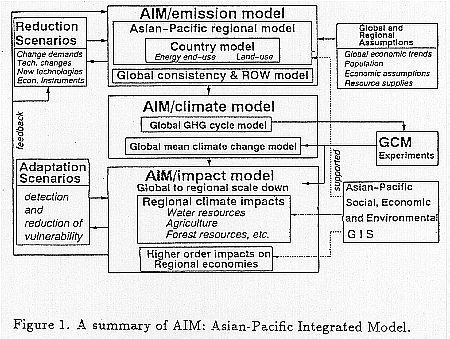
The AIM comprises three main models - the AIM/emission model for predicting greenhouse gas emissions, the AIM/climate model for estimating global and regional climate change, and the AIM/impact model for estimating the impacts of global warming. Figure 1 shows the relationships between these models (Matsuoka et al, 1994, Morita et al., 1993).
The AIM/emission model is comprised of Asian-Pacific country models and a World
model which ensures interactions between these regional models are consistent. The major component of the country model is an end-use energy demand model. The emission model combines an end-use energy model and a technological selection model. More than 100 technologies are evaluated for their potential to improve energy efficiency, and energy demand estimates are linked to a top-down economic model. So far, a prototype model has been completed and applied to Indonesia, China, and Japan.
The AIM/climate model is designed to link to other established models for calculating global and regional climate change. It comprises the revised AMAC model for atmospheric composition, the IPCC radiative forcing model, a box-diffusion ocean uptake model, the Rashof feedback model, and a model for regional scenarios of climate based on GCM outputs.
The AIM/impact model is designed to calculate the primary impacts on water supply, agricultural production, wood supplies, human health, etc., and then make predictions of higher-order impacts on the regional economy. The AIM/impact model is linked to the AIM/emission model through GCM experiments which are based on the greenhouse gas emission scenarios calculated by the AIM/emission model.
Various economic and environmental data for the region have been gathered and filed in a spatial data-base. Simulation models to estimate water resources changes, vegetation changes and malaria spread caused by global warming have been developed.
The AIM/emission model is comprised of Asian-Pacific country models which are integrated into a regional model. This in turn is linked to a Rest of the World model that ensures interactions between these regional models are consistent. A variety of global and regional assumptions about such things as population, economic trends, as well as government policies, are then entered into the model and interact with the regional and country models to provide estimates of energy consumption, land-use changes, etc. which ultimately give predictions of greenhouse gas emissions.
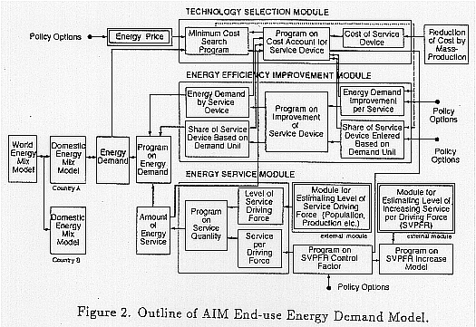
Figure 2 shows the outline of the country energy demand model. In each country model, energy demand is calculated by multiplying the energy service (calculated by the energy service sub-module) by an energy efficiency factor. This factor is determined by the energy efficiency sub-module, and is the product of assumptions made about the introduction of new technologies for energy conservation as influenced by energy prices. The technology selection sub-module decides which technologies will be introduced.
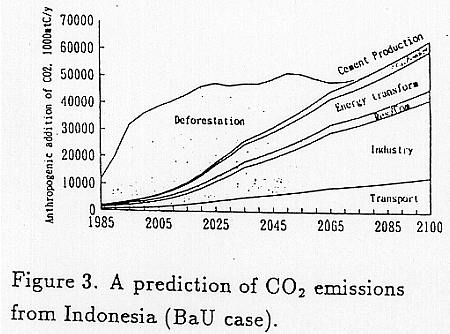
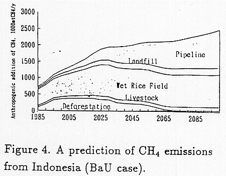
The Indonesian model uses an energy service model comprising four sectors; a transport sector, an industrial sector, a residential sector, and a commercial sector. In a "Business-as-Usual (BaU)" scenario, the improvement in energy efficiency was simply assumed to be linear, at the rate of about 1% per annum. Other major assumptions were: a population of 340 million at 2100; a GNP increase of 4.1% per annum up to 2125, followed by 3.3% per annum; an urbanization rate of 73%; and a deforestation rate of 2.2 million ha per year. Figure 3 and 4 show the predicted emissions of CO2 and CH4 over the next 100 years. CO2 emissions from deforestation increase until the early part of the next century and then decline as the remaining forests disappear. Emissions from other sources increase steadily, but at different rates. The main contributors of CH4 emissions will be rice cultivation and leaks from pipelines.
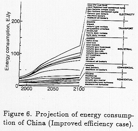
As with the Indonesian model, an energy service model of four sectors was used. However, estimates of energy efficiency improvements were the result of individual scenarios for each of 30 different technologies. In the "Business as Usual" case, these improvements ranged from 0.5-1.0% per annum. When allowances were made for energy conservation policy implementation, the improvements increased to a little more then 1% per annum. The population was assumed to grow to 1.66 billion at 2100, while the GNP growth rate was 5.3% per annum until 2025, then 3.9% per annum. Figure 5 illustrates the "Business as Usual" forecast, with energy consumption increasing from
25 EJ in 1985, to 170 EJ in 2050 and 250 EJ in 2100. If energy conservation policies are implemented as assumed, total energy consumption growth is half of the "Business as Usual" case. See Figure 6.
Development of the Japanese model is well-advanced. One main feature of this model is the integration of the technological selection module into the energy demand model. As described in the AIM outline, energy efficiency improvements depend on the introduction of energy conservation technologies, which in turn is influenced by energy price. More than 100 technologies for energy conservation used in the industrial, residential, commercial and transport sectors were examined, and their initial cost, maintenance cost, market share, energy conservation potential, pay back period, etc. were input into the model.
Scenarios up to the year 2010 were prepared for population growth, industrial production, as well as the expansion of the average household area and office floor space, and used as assumptions for predicting energy service demand. Computer simulations were made of five different situations:
If a carbon tax is introduced, energy consumption would be reduced, but this alone cannot stabilize total CO2 emissions. The combination of a carbon tax and a subsidy from recycling tax revenue would have a significant effect over the short term.
In summary, to stabilize CO2 emissions in Japan, we must introduce mutually-reinforcing policies, such as a combination of a carbon tax, extensions of pay back period, and subsidies.
All of the country models for the region have not yet been completed, but we have developed a rough emission model, not only for the regions of the Asian-Pacific, but also for six regions of the World. This regional emission model was developed using the Edmonds-Reilly model (1983), which is a partial equilibrium world model.
Using the rough model for these countries in conjunction with the detailed completed models, and making them consistent with the Rest of the World model, we prepared preliminary estimates of regional greenhouse gas emissions for the year 2100.
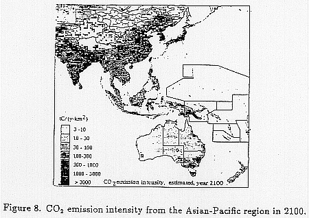
CO2 emission intensities are shown in Figure 8, When compared with the recent situation, the areas where major growth in CO2 emissions will occur can easily be identified. They include, Korea, China, Thailand, Malaysia, Indonesia, India and Bangladesh.
The AIM/climate model estimates the atmospheric concentration of greenhouse gases and the temperature increase. We have developed a world climate model using original linkages to join other established models. It comprises the revised AMAC
model for atmospheric composition, the IPCC radiative forcing model, a box-diffusion ocean uptake model, the Rashof feedback model, and a model for regional scenarios of climate change based on GCM outputs. The AIM/climate model was linked to the AIM/emission model to evaluate the effects of greenhouse gas emission increases on the climate. It is also planned to link to the AIM/impact model.
The regional climate change scenarios to be used in AIM/impact are mainly prepared by the GCMs. In order to apply these GCM experiments, their outputs were normalized by the difference between the global means of the equilibrium 2 x CO2 experiment and the 1 x CO2 experiment. This procedure eliminates equilibrium sensitivities of different models, and also allows the normalized result to be applied to time-dependent scenarios of global-mean warming produced by the AIM/emission model. These normalized climate change patterns are basically prepared in the GCM spatial resolutions. However, they are subsequently interpolated to a finer grid in order to correspond with the regional impact models of each sector. As the sub-grid interpolation of GCM outputs has a lot of problems, we are also intensively examining methods based on statistical relationships between broad-scale climatic data and small scale observations from regional climate records.
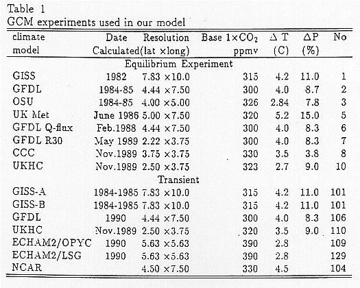
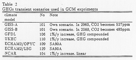
The GCM experiments we prepared now are shown in Table 1 and greenhouse gases transient scenarios used in GCM experiments are shown in Table 2. Some of them are
equilibrium experiments and others are transients. We normalize them and couple them with our simplified global GHG cycle model in order to calculate the spatially detailed climatic parameters under an arbitrary emission scenario.
The AIM/impact model estimates impacts of global warming in the Asian-Pacific region. AIM/ impact is comprised of a sea level rise model, a water balance model, a vegetation change model, a health impact model, a natural disaster model, an agriculture production model, and an economic evaluation model of global warming damage.
The outputs of the AIM/emission model will be entered into the AIM/climate model which will provide a variety of scenarios used in GCM experiments. Data from the GCM experiments will be used as the basic assumptions for the AIM impact model, and will reflect estimates of regional climate impact. The AIM/impact model will calculate the primary impacts on water supply, agricultural production, wood supplies, human health, etc., and then make predictions of higher order impacts on the regional economy.
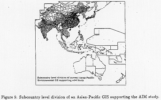
To function properly, our models require a high-quality spatial data-base. As such, we are developing the Asian-Pacific environmental, social and economic Geographical Information System (GIS). This GIS has a spatial segmentation at the sub-country level as shown in Figure 9. Information which comes from many international organizations, including the UNEP/GRID system as well as individual governments, is integrated with
our originally constructed data, and the information is organized in a format useful to support the AIM study.
Hydrological impacts are one of the most important aspects of the coming climate change. Changes in the magnitude, frequency and duration of hydrological factors influence the availability of water resources, flooding intensity as well as agricultural and natural terrestrial ecosystems. A rainfall-runoff process submodel was developed as one of the basic submodules of the AIM/impact model. This submodule consists of water balance and water transport components, and it is intended to provide basic hydrologic information to the impacts models of other sectors. Specifically, it creates gridded high resolution datasets of surface runoff, soil moisture, evapotranspiration and river discharge.
The major parameters of the hydrological model are elevation, soils, vegetation as well as precipitation, temperature, and potential evapotranspiration. Except for the first three, these parameters are endogenous variables of the total AIM system. As the coupling of the total system is not complete, we set soil and vegetation characteristics as well as elevation conditions at their current situations.
The water balance component of the model is based primary on the models of Thorn-
thwaite and Mather (1955) and their successors. Bookkeeping of the water balance among precipitation, snowmelt, evapotranspiration and streamflow is calculated for each grid cell in the simulation region. A number of climatological and geographical data sets were prepared from various sources. Precipitation and temperature values were taken from interpolated results of GCM experiments by GFDL. Soil moisture capacities were estimated using current vegetation classes and soil textures (Vorosmarty et al., 1989, Webb et al., 1993).
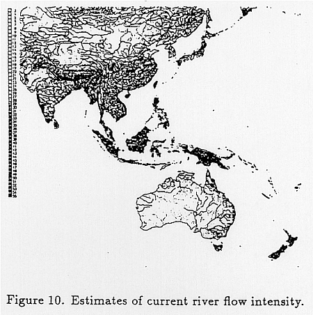
In the water transport component, the network topology of streams was determined from digital elevation data and modified with various hydrological maps of analyzed regions. Modelling of surface water retention time in each cell followed Vorosmarty's model (1989). Figure 10 is a result of estimating annually-averaged accumulated runoff under current climate conditions. The calculation was conducted with 1/4 degree grid cells. Climate data was taken from the monthly average data sets of Legates and Willmott (1989) with 1/2 degree resolution. The degree of shading in the figure expresses the intensity of discharge from a cell to the next one downstream. Black indicates the highest flow areas, and white indicates the areas of lowest flow.
Using this model as the base condition, we then applied outcomes of GCM experiments (GFDL Q-flux experiment as the perturbed climate scenario), which provide precipitation, temperature and soil humidity data. These experiments were based on a future CO2 level which is twice that of the Pre-industrial Revolution level. After interpolating the daily and monthly results of the GCM experiment, so they could be
overlaid with Legates climatic pattern which has a higher resolution than GCM outputs, these input conditions were used to prepare simulations of variability in the water discharge of each river basin. These simulations were conducted for a 10 year period after a 2 year initial simulation under each condition, and then the probability distributions of the monthly simulated discharges were identified in each grid cell. Based on these distributions, we estimated flood and drought severities over a 10 year period in the '' 2 x CO2 condition.
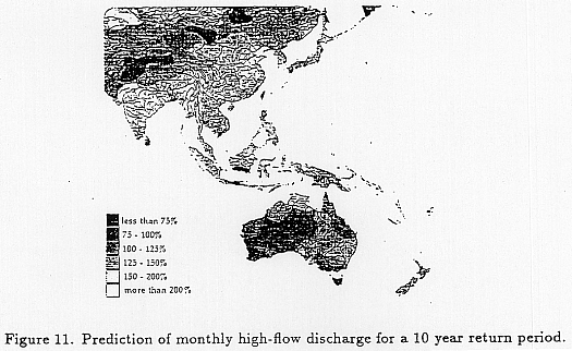
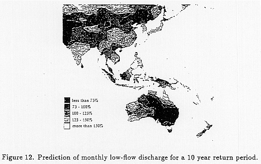
Figure 11 shows an output of such a simulation for flood discharge. The light gray shading indicates the area where the highest flow discharge level for a 10 year return period may be expected to exceed twice the current level. Parts of India, China, and Japan could experience much higher flood levels. Figure 12 shows the changes in low flow conditions over a 10 year period. The dark shading indicates areas where the lowest flow levels decrease by 40 or 50 %. As shown in the figure, large areas of the region are forecasted to experience much drier periods. The spatial pattern of influence was not sensitive to the selection of a return period. Intensification of flood discharge does not mean the relief of drought, and in fact, an increase in the incidence of both events is anticipated for some regions.
In order to assess the more direct impact of hydrological changes on the human dimension, we have to consider the effect of water control and management devices, as well as the intensity and style of water consumption. So far, we have estimated only population weighted average values of drought and flood intensities. It is still too in-
complete to comprehend the overall impacts of hydrological changes on human society. To clarify these impacts, we are now accumulating information about vulnerabilities to water related factors at the regional and subcountry levels.
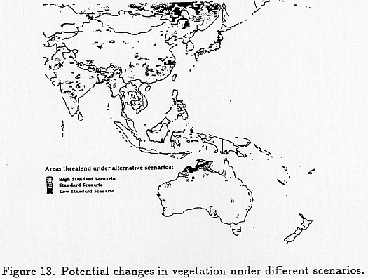
The spatial distribution of natural vegetation is strongly controlled by climate. Future climate change should have profound impacts on the distribution of vegetation patterns in the Asian-Pacific area. As a preliminary assessment of this impact, we established a simple model of global vegetation change caused by the change of related climate elements. In this model, a vegetation type is assumed to change if any climate element in its habitat exceeds the current global minimum or maximum level found in that vegetation habitat. As for climate elements, we used mean annual precipitation, mean annual temperature, coldest monthly temperature, hottest monthly temperature, and degree-days above 5°C.
Figure 13 shows the potential changes in vegetation under the several scenarios coupled with the results of GFDL-R30 GCM experiment. Significant changes in northern China are observed. Boreal conifer forests and larch taiga in this area are predicted to be significantly influenced. Tibetan and Himalayan alpine tundra would also be influenced. Evergreen-deciduous areas in Southeast China, drought-deciduous forests
in India, Indo-China Peninsula and Northern Australia would also adversely affected by climate change. These changes should be considered as potential shifts under equilibrium assumptions. The actual mechanism of succession is far more complex and dynamic. For a preliminary analysis, the above method is useful. However, we consider such a static model to be unsatisfactory and of limited use, so we are preparing dynamic population-based succession models.
Global warming will result in increases in the temperature and changes to the vegetation close to the ground. This will allow the habitat of the Anopheles mosquito, which is the malaria vector, to expand. As well, the development period of the malaria protozoan will shorten and its reproductive potential will increase. As a result, it is predicted that the global malaria risk will increase. In order to estimate the risk quantitatively, a global model has been developed.
The malaria risk increase is estimated in the model using the following steps:
We have developed the integrated model for the policy analysis of global warming. This model comprises the emission, climate and impact models. We completed the World models for emissions and climate and also developed some prototype countrywide models, and applied them to emission scenario analysis and policy evaluation. We plan to prepare country models for the Asian-Pacific region in cooperation with institutes in each country and develop the project on a regional basis.
We also have developed a water resource change model, a vegetation change model, and a health impact model. These models and the database used for simulation need to be improved to explain the complex and dynamic process of real mechanisms.
It is also necessary to develop some models to estimate other primary impacts caused by global warming. Based on these primary impact estimates, we plan to estimate higher order impacts on regional economies while taking into account the effects of international relations.
Alcamo, J., Kreileman, G.J.J., Krol, M. and Zuiema, G. (1993): Modelling the global society-biosphere-climate system: Part1: model description and testing, Papers of International Workshop on Integrative Assessment of Mitigation, Impacts and Adaptation to Climatic Change, 13-15, October, 1993, Laxenburg, Austria.
MIT (1994): Joint Program on the Science and Policy of Global Change, Center for Global Change Science and Center for Energy and Enviromental Policy Research, MIT, MA, USA.
Edmonds, J.A., Pitcher, H.M., Rosenberg, N.J. and Wigley, T.M.L. (1993): Design for the global change assessment model - GCAM, papers of International Workshop on Integrative Assessment of mitigation, Impacts and Adaptation to Climate Change, 13-15 October, 1993, Laxenburg, Austria.
Edmonds, J.A. and Reilly, J.M. (1983): Global energy and CO2 to 2050. The Energy Journal, Vol. 4, No. 3, pp.21-47.
Legates, D.R. and Willmott, C.J. (1989): Monthly Average Surface Air Temperature and Precipitation, Digital Data on a 0.5 degree Geographic 361 x 721 Grid, NCAR, Boulder, CO, USA.
Matsuoka, Y., Kainuma, M. and Morita, T. (1994): Scenario Analysis of Global Warming Using the Asian-Pacific Integrated Model (AIM), Integrative Assessment of Mitigation, Impacts and Adaptation to Climate Change (N. Nakicenovic et al. eds.), CP-94-9, IIASA, Austria, pp.309-338.
Morita,T., Matsuoka, Y., Kainuma, M., Harasawa, H. and Kai, K. (1993) AIM- Asian-Pacific Integrated Model for Evaluation policy options to reduce greenhouse gas emissions and global warming impacts. Proceedings of the Workshop on Global Warming Issues in Asia, Bangkok, 8-10 September, 26 pages.
Prather, M. (1988): Assessment Model for Atmospheric Composition, NASA Conference Publication 3023, NASA Goddard Institute for Space Studies, NY.
Thornthwaite, C.W. and Mather, J.R. (1955): The Water Balance, Publ. Climatol. Lab. Climatol. Drezel Inst. Technol., Vol. 8, No. 1, pp.1-104.
Vorosmarty, C.J., Morre III, B., Grace, A.L. and Gildea, M.P. (1989): Continental Scale Model of Water and Fluvial Transport: an Application to South America, Global Biogeochemical Cycle, Vol. 3, No. 3, pp.241-256.
Webb, R.S. and Rosenzweig, C.E. (1993): Specifying Land Surface Characteristics in General Circulation Models: Soil Profile Data Set and Derived Water-holding Capacities, Global Biogeochemical Cycle, Vol. 7, No. 1, pp.97-108.