|
|


This Web page groups together SEDAC-sponsored and other publications and reports that focus on remote sensing applications in urban areas, as well as providing links to useful resources.

| Publications and Reports | |||
| CIESIN's Thematic Guide to Night-time Light Remote Sensing and its Applications (2008). Written by Christopher Doll. |
|||
| CIESIN's Thematic Guide to Social Science
Applications of Remote Sensing (2002). Section 5.6 provides an overview on urban remote sensing applications. |
|||
| Nghiem, S., D. Balk, C. Small, U. Deichmann, A. Wannebo, R. Blom, P. Sutton, G. Yetman, R. Chen, E. Rodriguez, B. Houshmand, and G. Neumann (2001). Global Infrastructure: The Potential of SRTM Data to Break New Ground. White Paper produced by CIESIN and NASA's Jet Propulsion Laboratory. | |||
Potere, D. (2009). Mapping the World's Cities: An Examination of Global urban Maps and Their Implications for Conservation Planning. Dissertation in partial fulfillment of the PhD requirement at Princeton University, January 2009. |
|||
| Pozzi, F. and C. Small (2002). Vegetation and Population Density in Urban and Suburban Areas in the U.S.A. In Proceedings of the Third International Symposium of Remote Sensing of Urban Areas, 11-13 June 2002, Istanbul, Turkey, pp. 489-496. | |||
| Pozzi, F. and C. Small (2001). Exploratory Analysis of Suburban Land Cover and Population Density in the U.S.A. In Proceedings of the IEEE/ISPRS Joint Workshop on Remote Sensing and Data Fusion over Urban Areas, 8-9 November 2001, Rome, Italy, pp. 250-254. | |||
| Pozzi, F. (ed.) (July 2001). Remote Sensing Applications at the State and Local Level. Report of a SEDAC User Workshop by the same title, Palisades, NY, 23 February 2001. | workshop | ||
| Small, C. (2001). Global Analysis of Urban Population Distributions and the Physical Environment. Paper presented at the 2001 Open Meeting of the Human Dimensions of Global Environmental Change Research, Rio de Janeiro, October 2001. | |||
|
Small, C., and R.B. Miller. (2000). Spatiotemporal Monitoring of Urban Vegetation. Paper presented at the International Symposium on Remote Sensing of Environment, Capetown, South Africa, 2000. |
|||
| Small, C., and R.B. Miller. (1999). Monitoring the Urban Environment from Space. Paper presented at the International Symposium on Digital Earth, Beijing, 1999. | |||
| Other Resources | |||
|
The 100 Cities Project is a platform designed to bring policymakers and researchers together to apply urban remote sensing to the problems of urbanization, the environment, and sustainability. The project seeks to create meaningful partnerships with cities internationally to develop models of how best to address cities’ problems with urban remote sensing. At the same time we are developing relationships with academic researchers who produce urban remote sensing products and use them in their models. |
|||
| Dynamics of Global Urban Expansion This study examined the dynamics of global urban expansion by defining a new universe of 3,943 cities with population in excess of 100,000 and drawing a stratified global sample of 120 cities from this universe. Population data and satellite images for two time periods - a decade apart - were obtained and analyzed, and several measures of urban extent and expansion - among them the built-up area of cities and the average density of the built-up area - were calculated. |
|||
Global Rural-Urban Mapping Project (GRUMP) The Global Rural-Urban Mapping Project (GRUMP) provides a new suite of data products that add urban-rural specification to the Gridded Population of the World (see below). This project was developed out of a need for researchers to be able to distinguish population spatially by urban and rural areas. The central data product resulting from GRUMP is called Gridded Population of the World with Urban Reallocation (GPW-UR) on a 1km grid. Additional datasets resulting from GRUMP include a land area grid showing urban areal extents worldwide and a database of human settlements, their spatial coordinates, and populations. |
|||
|
This wiki grew out of an Expert Group Meeting on Slum Mapping, 21-23 May 2008, at ITC in Enschede, Netherlands organized by ITC and co-sponsored by CIESIN and UN-HABITAT. The focus of the meeting was to document methods for the identification and delineation of slum areas based on high resolution remote sensing and supplementary data sets, e.g. census and related GIS data on infrastructure and services. The wiki provides reports on that workshop and on subsequent meetings and development of collaborative slum mapping activities. |
|||
Gridded Population of the World (GPW) |
|||
|
LandScan |
|||
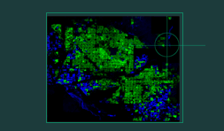
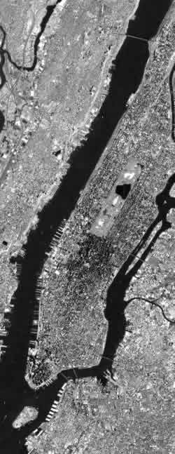
Urban Landsat: Cities from Space This Web site provides a collection of Landsat scenes processed by Christopher Small. There are 77 JPEG images of cities around the world, of which 28 cities have the actual Landsat scene for download. |
|||
| Urban
Remote Sensing Web site by Christopher Small, SEDAC Project Scientist and Remote Sensing Researcher, Lamont-Doherty Earth Observatory. |
|||