Data Sets (37)
|
1 of 2
Prev
|
Next
|
Annual Global High-Resolution Extreme Heat Estimates (GEHE), v1 (
|
Yale Center for Earth Observation (YCEO) Surface Urban Heat Islands, v4 (
|
|
Global (GL) Annual PM2.5 Grids from MODIS, MISR and SeaWiFS Aerosol Optical Depth (AOD), v4.03 (
|
Global Monthly and Seasonal Urban and Land Backscatter Time Series, v1 (
|
|
Population (POP), Built-Up Estimates (BUILT), and Degree of Urbanization Settlement Model Grid (SMOD), v1 (1975, 1990, 2000, 2014, 2015)Global Human Settlement Layer (GHSL)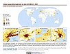
To provide global data on human population, built up area, and degree of urbanization for the years 1975, 1990, 2000, and 2014/2015 in the World Geodetic System 1984 (WGS84) geographic coordinate system. |
Global 1-km Downscaled Urban Land Extent Projection and Base Year Grids by SSP Scenarios, v1 (
|
|
VIIRS Plus DMSP Change in Lights (VIIRS+DMSP dLIGHT), v1 (1992, 2002, 2013)Satellite-Derived Environmental Indicators
To visualize changes in brightness and extent of global nighttime lights networks over two decades with improved radiometric accuracy and finer spatial resolution. |
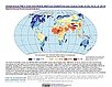
Global Human Modification of Terrestrial Systems, v1 (2016)Land Use and Land Cover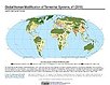
To provide a cumulative measure of human modification of terrestrial lands based on modeling the physical extents of 13 anthropogenic stressors and their estimated impacts using spatially-explicit global data sets. |
|
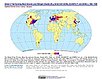
Global Development Potential Indices, v1 (2016)Land Use and Land Cover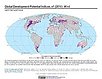
To provide spatially-explicit data that relatively rank global land suitability referred to as Development Potential Indices (DPIs) for 13 sectors related to renewable energy, fossil fuels, mining and agriculture as an aid to conservation priority setting. |
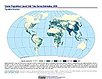
Development Threat Index, v1 (2015)Land Use and Land Cover (LULC)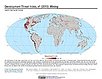
To provide a future development threat map based on combining these resources: agricultural expansion, urban expansion, conventional oil and gas, unconventional oil and gas, coal, mining, biofuels, solar, and wind. |
|
Urban Extents from VIIRS and MODIS for the Continental U.S. Using Machine Learning Methods, v1 (2015)Urban Spatial Data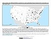
To provide representations of urban areas in the Continental U.S. in the year 2015 to support sustainable urban development planning in accordance with the growth of urban areas. |
Subset of JRC Map of Accessibility, v1 (
|
|
Subset of DMSP-OLS Nighttime Lights for Economic Activity, v1 (2010)West Africa Coastal Vulnerability MappingTo provide a measure of economic activity in the coastal zone of West Africa based on nighttime lights. |
Economic Systems Index, v1 (2000, 2010)West Africa Coastal Vulnerability MappingTo assess relative levels of economic activity in the coastal zone of West Africa. |
|
Global Human Built-up And Settlement Extent (HBASE) Dataset From Landsat, v1 (2010)Global High Resolution Urban Data from Landsat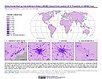
To provide high spatial resolution estimates of global urban extent derived from global 30m Landsat satellite data for the target year 2010 and a companion dataset to the Global Man-made Impervious Surface (GMIS) dataset. |
||
Global Man-made Impervious Surface (GMIS) Dataset From Landsat, v1 (2010)Global High Resolution Urban Data from Landsat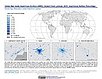
To provide high spatial resolution estimates of global man-made imperviousness for the target year 2010, derived from global 30m Landsat satellite data and a companion dataset to the Global Human Built-up And Settlement Extent (HBASE) dataset. |
Global Summer Land Surface Temperature (LST) Grids, v1 (2013)Satellite-Derived Environmental Indicators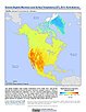
To provide raster representations of global summer daytime maximum and nighttime minimum surface temperature for studies related to human health and climate change. |
|
1 of 2
Prev
|
Next
|