Data Sets (41)
| 2 of 3 |
Gridded Subset of Sub-national Poverty and Extreme Poverty Prevalence, v1 (2005)West Africa Coastal Vulnerability MappingTo provide poverty levels in the coastal zone of West Africa. |
Deforestation, v1 (
|
|
Subset of DMSP-OLS Nighttime Lights for Economic Activity, v1 (2010)West Africa Coastal Vulnerability MappingTo provide a measure of economic activity in the coastal zone of West Africa based on nighttime lights. |
Commercial Crop Production, v1 (2000)West Africa Coastal Vulnerability MappingTo provide crop production for five higher-value export crops in West Africa to aid in estimating production value. |
|
Economic Systems Index, v1 (2000, 2010)West Africa Coastal Vulnerability MappingTo assess relative levels of economic activity in the coastal zone of West Africa. |
Point and Gridded Locations of Fatalities, v1 (
|
|
Global Summer Land Surface Temperature (LST) Grids, v1 (2013)Satellite-Derived Environmental Indicators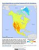
To provide raster representations of global summer daytime maximum and nighttime minimum surface temperature for studies related to human health and climate change. |
Global Flood Hazard Frequency and Distribution, v1 (
|
|
Global Drought Total Economic Loss Risk Deciles, v1 (2000)Natural Disaster Hotspots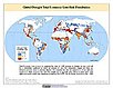
To provide a spatial surface of the total economic impacts of global drought hazard. |
Global Drought Proportional Economic Loss Risk Deciles, v1 (2000)Natural Disaster Hotspots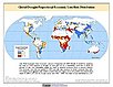
To provide a spatial surface of the proportional economic impacts of global drought hazard. |
|
Global Drought Mortality Risks and Distribution, v1 (2000)Natural Disaster Hotspots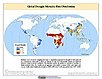
To provide a means of assessing global drought mortality risks and distribution. |
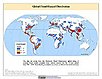
Global Flood Total Economic Loss Risk Deciles, v1 (2000)Natural Disaster Hotspots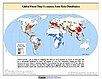
To provide a spatial surface of the total economic impacts of global flood hazard. |
|
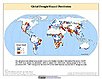
Global Flood Proportional Economic Loss Risk Deciles, v1 (2000)Natural Disaster Hotspots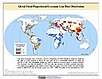
To provide a spatial surface of the proportional economic impacts of global flood hazard. |
Global Flood Mortality Risks and Distribution, v1 (2000)Natural Disaster Hotspots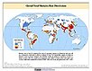
To provide a means of assessing global flood mortality risks and distribution. |
|
Global Drought Hazard Frequency and Distribution, v1 (
|
MA Climate and Land Cover, v1 (
|
|
MA Ecosystems, v1 (2000)Millennium Ecosystem Assessment (MA)To preserve access to the original ecosystems data used by the Millennium Ecosystem Assessment (MA) and other related research. |
Global Mangrove Forests Distribution, v1 (2000)Land Use and Land Cover
To provide data that can be used in global mangrove forest distribution modeling, land cover change analysis, global carbon accounting studies and to assist with policy-making in regards to human-environment interactions and future adaptive strategies. |
|
Global 15 x 15 Minute Grids of the Downscaled Population Based on the SRES B2 Scenario, v1 (1990, 2025)Socioeconomic Downscaled Projections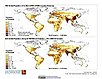
To provide a gridded data on country-level population and downscaled projections based on the SRES B2 marker scenario. |
Global 15 x 15 Minute Grids of the Downscaled GDP Based on the SRES B2 Scenario, v1 (1990, 2025)Socioeconomic Downscaled Projections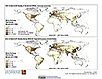
To provide gridded GDP data on country-level downscaled projections based on the SRES B2 marker scenario. |
| 2 of 3 |