Data Sets » Theme: Marine and CoastalRemove Facet
2 of 2
Prev | Next

Economic Systems Index, v1 (2000, 2010)

West Africa Coastal Vulnerability Mapping

To assess relative levels of economic activity in the coastal zone of West Africa.

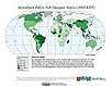
Point and Gridded Locations of Fatalities, v1 (2008 – 2013)

West Africa Coastal Vulnerability Mapping

To measure human security and sensitivity of populations to climate stressors in the coastal zone of West Africa.

Environmental Performance Index, 2018 Release (1950 – 2018)

Environmental Performance Index (EPI)

To provide quantitative metrics for evaluating a country's environmental performance in different policy categories relative to clearly defined targets.

Fifth Assessment Report (AR5) Observed Climate Change Impacts, v2.01 (2007 – 2014)

Intergovernmental Panel on Climate Change

To provide a database with observed responses to climate change for multidisciplinary studies.

Environmental Performance Index, 2016 Release (1950 – 2016)

Environmental Performance Index (EPI)

To provide quantitative metrics for evaluating a country's environmental performance in different policy categories relative to clearly defined targets.

Environmental Performance Index, 2014 Release (2002 – 2014)

Environmental Performance Index (EPI)

To provide quantitative metrics for evaluating a country's environmental performance in different policy categories relative to clearly defined targets.

Sea Level Rise Impacts on Ramsar Wetlands of International Importance, v1 (2000 – 2010)

Low Elevation Coastal Zone (LECZ)

To provide a preliminary assessment of coastal Ramsar Sites that are at risk to inundation as a consequence of sea level rise.

Urban-Rural Population and Land Area Estimates, v2 (1990, 2000, 2010, 2100)

Low Elevation Coastal Zone (LECZ)

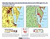
To provide estimates of urban and rural populations and land areas for the years 1990, 2000, and 2010; and projections to the year 2100 for 202 countries with contiguous coastal elevations in the following categories: less than or equal to 1m, 3m, 5m, 7m, 9m, 10m, 12m, or 20m; as well as national totals.

Environmental Performance Index and Pilot Trend Environmental Performance Index, 2012 Release (2000 – 2010)

Environmental Performance Index (EPI)

To provide quantitative metrics for evaluating a country's environmental performance in different policy categories relative to clearly defined targets.

Environmental Performance Index, 2010 Release (1994 – 2009)

Environmental Performance Index (EPI)

To provide quantitative metrics for evaluating a country's environmental performance in different policy categories relative to clearly defined targets.

Annual Chlorophyll-a Concentration, v1 (1998 – 2007)

Indicators of Coastal Water Quality

To provide a gridded version of existing SeaWiFS data in GIS-compatible formats in order to determine concentrations of chlorophyll-a in the coastal water column and to facilitate the integration with other data.

Change in Chlorophyll-a Concentration, v1 (1998 – 2007)

Indicators of Coastal Water Quality

To provide tabular data on the trends of chlorophyll-a concentration on a pixel by pixel basis for identifying areas with improving, declining, and stable coastal water quality that can provide guidance for decision making in the context of coastal management.

Fourth Assessment Report (AR4) Observed Climate Change Impacts, v1 (1970 – 2014)

Intergovernmental Panel on Climate Change

To provide a database with observed responses to climate change for multidisciplinary studies.

Environmental Performance Index, 2008 Release (1994 – 2007)

Environmental Performance Index (EPI)

To provide quantitative metrics for evaluating a country's environmental performance in different policy categories relative to clearly defined targets.

Urban-Rural Population Estimates, v1 (1990, 1995, 2000)

Low Elevation Coastal Zone (LECZ)

To provide estimates of urban and rural populations and land areas in the low elevation coastal zone.

Complete Collection, v1.01 (1973 – 2005)

Compendium of Environmental Sustainability Indicators

To make the acquisition, comparison and analysis of sustainability indicators easier by compiling them in a single database, incorporating multiple country codes, and condensing the indicator descriptions into short methodological summaries in an accompanying data dictionary.

MA Ecosystems, v1 (2000)

Millennium Ecosystem Assessment (MA)

To preserve access to the original ecosystems data used by the Millennium Ecosystem Assessment (MA) and other related research.

Global Mangrove Forests Distribution, v1 (2000)

Land Use and Land Cover

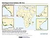
To provide data that can be used in global mangrove forest distribution modeling, land cover change analysis, global carbon accounting studies and to assist with policy-making in regards to human-environment interactions and future adaptive strategies.

Coastlines, v3 (2000)

Gridded Population of the World (GPW), v3

To provide a set of coastlines consistent with GPWv3 raster data for cartographic purposes.

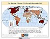
The Wellbeing of Nations, v1 (1990 – 2000)

Compendium of Environmental Sustainability Indicators

To provide data that address the key issues of sustainability by combining indicators of human wellbeing with those of environmental sustainability to generate a more comprehensive picture of the state of the world.

Data Sets » Theme: Marine and CoastalRemove Facet
2 of 2
Prev | Next