Climate Impacts, Vulnerability, and Adaptation
| 4 of 5 |
Population, Landscape, And Climate Estimates (PLACE), v2 (1990, 2000)National Aggregates of Geospatial Data Collection (NAGDC)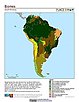
To provide tabular data on environmental conditions (elevations, climate, coastal) in which people reside. |
Global Mangrove Forests Distribution, v1 (2000)Land Use and Land Cover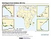
To provide data that can be used in global mangrove forest distribution modeling, land cover change analysis, global carbon accounting studies and to assist with policy-making in regards to human-environment interactions and future adaptive strategies. |
|
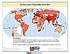
Environmental Sustainability Index, 2005 Release (
|
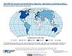
Environmental Performance Index, 2020 Release (
|
|
Environmental Performance Index and Pilot Trend Environmental Performance Index, 2012 Release (
|
Environmental Performance Index, 2014 Release (
|
|
Environmental Performance Index, 2016 Release (
|
Environmental Performance Index, 2018 Release (
|
|
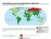
Potential Impacts of Climate Change on World Food Supply, v1 (
|
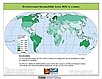
Environmental Vulnerability Index (EVI), 2004 Release (
|
|
Environmental Performance Index, 2022 Release (
|
Twentieth Century Crop Statistics, v1 (
|
|
Dams, v1.01 (2011)Global Reservoir and Dam (GRanD), v1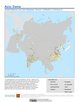
To provide a geographically explicit and reliable database of dams for the scientific community. |
Global 15 x 15 Minute Grids of the Downscaled Population Based on the SRES B2 Scenario, v1 (1990, 2025)Socioeconomic Downscaled Projections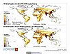
To provide a gridded data on country-level population and downscaled projections based on the SRES B2 marker scenario. |
|
Global 15 x 15 Minute Grids of the Downscaled GDP Based on the SRES B2 Scenario, v1 (1990, 2025)Socioeconomic Downscaled Projections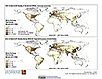
To provide gridded GDP data on country-level downscaled projections based on the SRES B2 marker scenario. |
Reservoirs, v1.01 (2011)Global Reservoir and Dam (GRanD), v1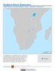
To provide a geographically explicit and reliable database of reservoirs for the scientific community. |
|
MA Ecosystems, v1 (2000)Millennium Ecosystem Assessment (MA)To preserve access to the original ecosystems data used by the Millennium Ecosystem Assessment (MA) and other related research. |
Country-Level GDP and Downscaled Projections Based on the SRES A1, A2, B1, and B2 Marker Scenarios, v1 (
|
|
Country-Level Population and Downscaled Projections Based on the SRES B2 Scenario, v1 (
|
Country-Level Population and Downscaled Projections Based on the SRES A1, B1, and A2 Scenarios, v1 (
|
| 4 of 5 |