Climate Impacts, Vulnerability, and Adaptation
| 3 of 5 |
Global Flood Mortality Risks and Distribution, v1 (2000)Natural Disaster Hotspots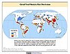
To provide a means of assessing global flood mortality risks and distribution. |
Global Drought Hazard Frequency and Distribution, v1 (
|
|
Altimeter Corrected Elevations (ACE2), v2 (
|
Subset of OpenStreetMap Roads, v1 (2014)West Africa Coastal Vulnerability MappingTo provide roads linking rural production to urban markets in the coastal zone of West Africa that represent an important exposed infrastructure asset. |
|
Subset of Global Mammal and Amphibian Richness Grids, 2015 Release (2013)West Africa Coastal Vulnerability MappingTo provide areas of higher richness of threatened species which may be at risk from climate stressors in the coastal zone of West Africa. |
Subset of High and Low Resolution Altimeter Corrected Elevations 2 (ACE2), v1 (
|
|
Social Vulnerability Indices, v1 (1997, 2005, 2008, 2010, 2013)West Africa Coastal Vulnerability MappingTo provide a measure of social vulnerability and "defenselessness" in the face of climate stressors in the coastal zone of West Africa. |
Mangrove Forests Distribution Polygon, v1 (2000)West Africa Coastal Vulnerability MappingTo provide mangrove forests in the coastal zone of West Africa that may be exposed to the threats of sea level rise and storm surge. |
|
GPWv4 Population Growth Preliminary Release, v1 (
|
Population Projections, v1 (2030, 2050)West Africa Coastal Vulnerability MappingTo provide areas in West Africa that may be particularly exposed to climate stressors owing to future high population growth. |
|
GPWv4 Population Density Preliminary Release, v1 (2010)West Africa Coastal Vulnerability MappingTo provide areas in the coastal zone of West Africa that may be particularly exposed to climate stressors owing to high population density. |
Demographic and Health Survey Data Sets, v1 (
|
|
Gridded Subset of Sub-national Poverty and Extreme Poverty Prevalence, v1 (2005)West Africa Coastal Vulnerability MappingTo provide poverty levels in the coastal zone of West Africa. |
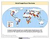
Deforestation, v1 (
|
|
Subset of DMSP-OLS Nighttime Lights for Economic Activity, v1 (2010)West Africa Coastal Vulnerability MappingTo provide a measure of economic activity in the coastal zone of West Africa based on nighttime lights. |
Commercial Crop Production, v1 (2000)West Africa Coastal Vulnerability MappingTo provide crop production for five higher-value export crops in West Africa to aid in estimating production value. |
|
Economic Systems Index, v1 (2000, 2010)West Africa Coastal Vulnerability MappingTo assess relative levels of economic activity in the coastal zone of West Africa. |
Point and Gridded Locations of Fatalities, v1 (
|
|
Population, Landscape, And Climate Estimates (PLACE), v4 (2000, 2005, 2010, 2015, 2020)National Aggregates of Geospatial Data Collection (NAGDC)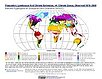
To provide tabular data to researchers without GIS capabilities who need data on population and land area by country across a range of physical characteristics. These include measures such as the number of persons living within coastal zones, the total area within a specific elevation strata, or the number of persons living within different climate zones. |
Population, Landscape, And Climate Estimates (PLACE), v3 (1990, 2000, 2010)National Aggregates of Geospatial Data Collection (NAGDC)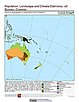
To provide tabular data to researchers without GIS capabilities who need data on population and land area by country across a range of physical characteristics. These include measures such as the number of persons living within coastal zones, the percent of a region within specific elevation strata, or the number of persons living within different climate zones. |
| 3 of 5 |